The major difference in the accuracy level achieved today in a receiver is the processing techniques. This is driven by the error level on the range measurements. (See Accuracy Factors.) For standalone users, the extent use of phase is a major factor.
The noise on the phase is typically 1 mm, that on the range 10 cm to 1 m. Therefore the use of phase data in any one of several ways can improve the solution. The multipath is also drastically reduced for the phase measurement.
The second technique to remove errors is differential GPS. Here errors in the signal outside the antenna are observed at a reference station. Those errors are sent to the user by one of several methods. For realtime users this can be the US Coast Guards "beacon" transmitters, or a commercial system using satellite communication links or FM subcarriers etc. These are usually L1 only systems.
The post processed differential user typically uses L1 and L2 data from high end receivers. Special techniques (called Kinematics) make use of the phase to achieve very high accuracies . However they normally can only be used out to ranges of 25 to 50 km. Many manufacturers of high end receivers have vendor specific real time version of this. You almost always have to have the same type of receiver at each end and a dedicated communication link.
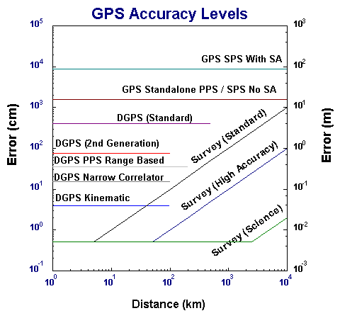
The PPS accuracy level is specified to be 16 m, spherical error probable (SEP). GPS position errors are always about twice as bad in height as along either horizontal axis. This means a horizontal error of about 10 m. The graph below lists the official current level. The actual level is much less. Horizontal errors for PPS (and SPS) in the 3-5 m range are common.
Since Selective Availability was turned off, the main operational difference between the civilian and military systems (SPS vs PPS) is the availability of a L2 for real time removal of the ionosphere. Inexpensive receivers with only L1 still have to deal with the ionosphere that mainly affects the height. Even this difference is removed for the more expensive receivers that use complex techniques to track L2.
The civilian (SPS) level is set by DoD policy. When the intentional degradation of accuracy was in place (called Selective Availability or SA) SPS accuracy was 100 m horizontal 5 % of the time ( 2 standard deviations). On May 1 2000, SA was set to a level of 0 -- effectively being turned off.
The graph shows the accuracy levels of all currently available systems. The vertical axis is the expected accuracy or error level, shown both in centimeters and meters. The horizontal axis is the distance along the earth's surface between the reference station and the remote user. If there is no reference station, the line is drawn all the way to 10,000 km, all over the earth.
The accuracy obtained in this way depends mainly on the:
These are listed in decreasing order of importance. The last factor, multipath, involves signals reaching the antenna both from a direct path to the satellite and from a path that bounces off some reflector. Multipath is normally tightly controlled at reference sites by careful antenna site selection. This is not included in the chart.
The next level, labeled second generation, began coming on line about 1990. This generation achieved "sub-meter" accuracy, about 70 to 100 cm. It uses about a 5 - 10 sec update cycle. Multipath is now an important consideration.
In 1990, a small firm specializing in high bandwidth digital communications, came up with a new approach to measuring ranges in GPS. This was called the "narrow correlator" technology. It has a narrow correlator in the time domain, making use of the sharp transition of bit edges. The receiver measurement noise was reduced by a factor of 5 initially.
Using narrow correlator techniques, and the civilian SPS signals, 20 cm DGPS has been demonstrated using only ranging signals. This has been done even in aircraft. The communications rate requirement goes up to 1 Hz for aircraft applications. There are now several manufacturers achieving 10 cm accuracy levels.
Between these last two generations of commercial systems is the best current military (PPS) based DGPS. At the Naval Postgraduate School, 35 cm DGPS has been achieved using PPS signals. An important side benefit of PPS is a low communication rate for this accuracy, once per few minutes. This benefit became available to the SPS when SA was turned off.
There is another measurement available in GPS. This is usually called the Phase Variable. It has less than 1 mm of noise and is affected less by multipath. There are some technical drawbacks, mainly having to do with initializing a solution and high communications rates. It has been used from the mid 1980's in a post processing mode and since 1990 has been used real time. It is usually call "Kinematic" DGPS. Using either the civilian or military system, 5 cm accuracies can be achieved in aircraft after initialization.
The following is an example of DGPS errors taken with a 1996 vintage receiver. Although the Ashtech Z12 used is a dual frequency receiver, the real time DGPS output only uses L1 C/A code.
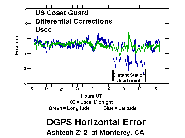
Notice that late at night US Coast Guard stations from far away, over 1000 km in this case, can be picked up and used. This causes a large increase in the error. There were other single frequency 12 channel receivers using the same DGPS data stream. They had the same pattern.