There are two factors that determine the accuracy of a GPS
position:
The first factor, the error on a measurement, has may components that are controlled by the receiver and the local environment of the system. The geometry to the satellites is basically not under the control of the user, except by using a receiver with more channels. The two effects enter as two factors in an equation for the position error. The commonly quoted parameter is the "DOP" (dilution of precision). This represents the geometric factor.
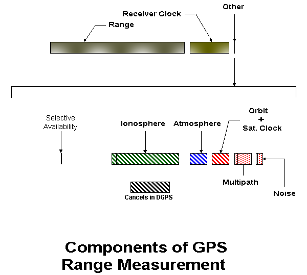
The following diagram of the a receiver range measurement shows the components approximately to scale. The true range to the satellites is about 20,000 km ( 3 times the radius of the earth ).
While the true range is the major component of a range measurement, it is rivaled by the effects of the local receiver clock error. Clearly this enormous error must be carefully measured and eliminated. This is done by including the receiver clock error as an unknown that is estimated at the same time as the position of the receiver. This is what makes a GPS solution a 4 dimensional problem. This estimation is done at every timeline that a position is computed.
The remainder of the errors in the range signal contribute directly to the position error. They are all very small compared to the range and receiver clock error, but very important to accuracy. These are contained in the small sliver on the top line which is expanded on the lower line. Several are variable, depending on the local time, and the receiver.
This error was intentionally injected onto the GPS signals at the satellites. It was turned off on May 1, 2000.
This error is a function of the local time of day and latitude. It is largest in the tropics in afternoon where it can be up to 30 m along a path near the horizon. Late at night it may be under a meter. The variation is indicated in the figure with a vertical bar within this component.
The ionosphere is eliminated through the use of dual frequency receivers. The second signal frequency, denoted L2, is present on GPS satellites precisely to remove the ionospheric effects. Most PPS receivers types are dual frequency. (The PLGR is an exception.)
Unfortunately the L2 frequency does not currently have the signal intended for use by the Standard Positioning Service (the CA code). Thus all CA receivers must deal with the ionospheric error. In the future ( about 2003-2005 ) new satellites will begin to have the CA signal on L2 as well as a new frequency for civilian use, named L5. When this happens, the ionosphere will effectively be removed as an error source except for older receivers.
Several hardware techniques have been developed in the civilian community to receive L2 range signals despite them being encrypted. These receivers are usually more expensive than CA receivers ( $10,000 in 2000 and decreasing. )
This error is essentially a function of the weight of the atmosphere above the user. It is therefore easily modeled using the atmospheric pressure. The total value of this error looking straight up is 2.3 m. Therefore it is usually not a factor in position accuracy. Receivers can model it to a few centimeters knowing only the altitude.
In order to navigate, the user needs to know the origin of the ranges he is measuring, that is the satellite position. The satellites broadcast this. However this information is just read out of a memory on the satellite. It is usually loaded in once a day from the computation center in Colorado Springs. Therefore this will be a prediction of where the satellite will be. It is in error due to many factors. In discussing this error, the selective availability is not considered, as it was included above.
In addition to the satellite position, the satellite clock offsets are also broadcast. The satellite atomic clocks drift off, but the Air Force GPS Ground system monitors this error and includes in the broadcast of the satellite position, the precise offset of each satellites clock from Universal Time (UTC).
These two components are currently the limiting error components in the GPS receivers using the Precise Positioning System. If Selective Availability is removed, this will be true for all real time users.
For very precise work, both civilian science workers and the military produce post fit orbit and satellite clock estimates. These usually are available one to two weeks after the fact. Several civilian Precise Ephemeris (PE's) are available on the internet. (See the US Coast Guard Information Center for example.)
The signal from the satellite comes along the direct line of sight between the user's antenna and the satellite. As the satellites can be anywhere in the upward hemisphere. Most GPS antennas can receive signals from anywhere above the horizon or above some low elevation angle (say 10 degrees).
In addition to this direct path, the signal can bounce off metal surfaces and reach the antenna along other paths. This is multipath. In practice antennas have some sensitivity to signals even from below, so multipath can be quite extensive. The receiver can only measure the sum of all these signals, and will have some error due to the antenna picking up this reflected energy.
It is important to note that this is a function of how 'clean' the antenna location is. Therefore it is highly variable. Multipath often is the dominate error source in DGPS applications.
In addition to the antenna siteing, the user has several other hardware options. Antennas are available that reject most of the multipath. They do this at the expense of seeing any satellites at low elevation angles. Since 1993, there have been receiver techniques that minimize multipath. These are usually available only in the more expensive receivers and then only at extra cost.
Every object that is not at absolute zero radiates electromagnetic energy over a broad band. Some of this is at the GPS frequencies. This will contribute a range error to the measurement. It is called "thermal noise". For GPS in the most precise receivers it use to be about 1 m. This is now only true of receivers that use technology from the first two generations of receivers. The newer technology is generally not usually used on the least expensive receivers.
The new receiver technology, usually called 'narrow correlator' technology, has thermal noise range errors one tenth that of the original GPS receiver. That is 10 cm or less.
In this figure is an example of the latitude error from two receivers on the same antenna. This data was taken while SA was on. One receiver was a civilian SPS receiver, the other a military PPS receiver. The larger errors going up to 50 m are the civilian SPS results. The small error are the PPS ones.

One can see that the SPS errors are not constant in time, but oscillate. The oscillations are not at a fixed frequency however.
The PPS errors exhibit jumps that correspond to the shifting of the set of satellites tracked. The noise within each small track segment is much less than a meter, but there is a bias of a few meters in each segment. This 'bias' seems to have a slow drift with time in some cases. This is due to the orbit and satellite clock errors. The error is essentially a random number for each satellite that slowly varies with time. It is smallest at satellite data upload (about 1.5 m one standard deviation) and grows to about a 4 m standard deviation after 24 hours.
Differential GPS works because many of these range errors will be the same at two receivers that are close to each other. Here close can be several hundred km. A reference station is set up over a know site. The errors in the range measured at this site are then broadcast over some communication link, to users in the area. These 'corrections' are broadcast for each satellite in view.
The following table shows which errors cancel completely and which are a function of the distance between the reference site and user.
ERROR........................... DGPS CANCELLATION
Selective Availability..............Completely
Ionosphere..........................Function of Distance
Atmosphere..........................Function of Distance
Orbit + Sat. Clock..................Completely
Multipath...........................Does Not Cancel
Receiver Noise......................Does Not Cancel