OC4331-Mesoscale
Oceanography
Final Project Summary
Topic Area
Kuroshio Current
Project Team Member
LT R. Corey Cherrett, USNR
Major Findings
The Kuroshio Current begins near the Philippines where the North Equatorial
Current ends and splits into two currents. The Kuroshio Current, being the
northward flowing current, flows along the Luzon coast, past Taiwan, into the
East China Sea, back into the Philippine Sea south of Japan, along the Japanese
coast, and then finally into the North Pacific Ocean east of Japan.
This study of the Kuroshio current divides the Kuroshio current into four
segments to ease discussion. Those for segments and the most important aspects
of their mesoscale phenomenon are as follows:
1) Phillipine Sea/South China Sea Intrusion (Fig 1)
- Kuroshio path oscillates between near straight path east of Luzon Strait
and a path that intrudes into South China Sea.
- An anticyclonic (warm core) ring forms from intrusion.
- Ring Shedding occurs between 3 and 4 times per year at about 119.5 E.
- Maximum speed of ring current about 1 m/s. Vertical extent 1000m+.
Dimensions 120km X 180km.
2) East China Sea (Fig 1).
- Predominent flow northeast along shelf break towards Kyushu.
- Flow into shelf forces warm water up onto shelf floor encirling
cooler/fresher ECS water creating meanders and eddies.
- Entrainment of ECS water. About 7% of heat and salt lost to marginal
seas from this process.
- Shoaling near Kyushu turns current towards east due to potential
vorticity conservation.
3) Philippine Sea near Japan/Kuroshio Meander (Fig 2).
- Kuroshio exiting Tokara Strait feels shelf break, experiences
stretching, and turns cyclonically towards north along the topography and
follows coast until about 136 E.
- Cyclonic turning and warm core eddy from Philippine Sea form dipole near
Kyushu which advects up coast. This dipole sometimes triggers Large Meander.
Transition from N-type flow to A-type flow is rapid.
- Large Meander is stable with average lifespan of 12.7 months.
- Decay of Large Meander is slower, transitioning through B-type then
C-type before returning to N-type.
- Current speed between 0.65 and 1.45 m/s with maximum located just south
of Shikoku.
4) North Pacific Ocean/Kuroshio Extension (Fig 3).
- Kuroshio turns east at about 35 degrees N and runs parallel to the
Oyashio current(Western Boundary Current from the North Pacific Subarctic
Gyre).
- The warm and cold currents form a strong frontal feature which causes
baroclinic instabilites and create eddies and rings (region of high Eddy
Kinetic Engery). One to two cyclonic eddies are formed each year.
- Bifurcation as current nears the Shatsky Rise.
- Current breaks up into filaments near the Emperor Seamounts, eventually
forming elements of the North Pacific Current.
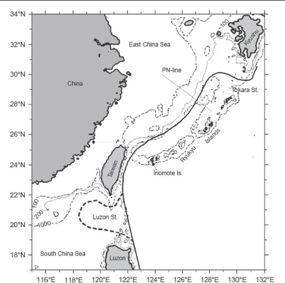
Figure 1.
Segment 1 and segment 2 of Kuroshio. Dotted line indicates SCS intrusion.
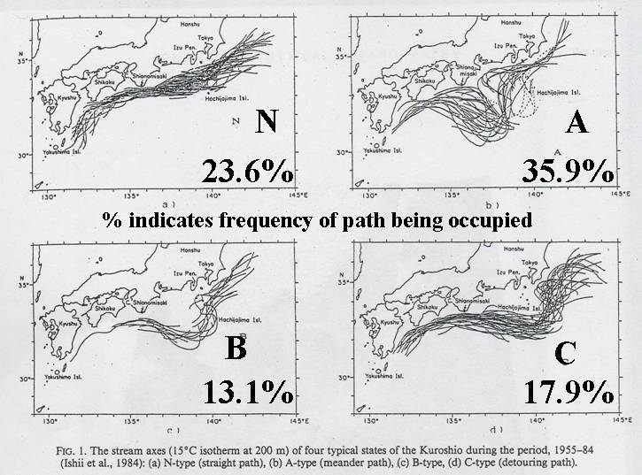
Figure
2. Four stages of Large Kuroshio Meander as indicated by drifter data.
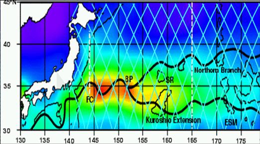
Figure 3.
Kuroshio Extention. Warm colors indicate high EKE.
Cherrett Kuroshio PPT File
References
Y. Hsueh, 2000: “The Kuroshio in the East China Sea”, Journal of Marine
Systems, Vol.24, 131-139.
Li Li, Worth D. Nowlin, Jr., Su Jilan, 1998: “Anticyclonic Rings from the
Kuroshio in the South China Sea”, Deep Sea Research I, Vol.45,
1469-1482.
Yinglai Jia, Qinyu Liu, 2004: “Eddy Shedding from the Kuroshio Bend at Luzon
Strait”, Journal of Oceanography, Vol.60, 1063-1069.
Tangdong Qu, Humio Mitsudera, Bo Qiu, 2001: “A Climatological View of the
Kuroshio/Oyashio System East of Japan”, Journal of Physical Oceanography,
Vol.31, 2575-2589.
Nikolai Maximenko, 2002: “Index and Composites of the Kuroshio Meander South
of Japan”, Journal of Oceanography, Vol.58, 639-649.
Jong-Hwan Yoon, Ichiro Yasuda, 1987: “Dynamics of the Kuroshio Large Meander:
Two-Layer Model”, Journal of Physical Oceanography, Vol.17,
66-81.
|
This is a government-maintained internet site. Please read the U.S.
Navy web page disclaimer
and the dislaimer regarding external
links. |
|