Topic Area
Identifying Ocean Fronts and Eddies with Satellite Altimetry
![]() Project Team Member(s)
Project Team Member(s)
LCDR Keith Williams, USN
![]()
Major Findings
- Sea surface height is measured from satellite using radar. Because the time versus position
(ephemeris) of the satellite is known for each measurement, atmospheric
corrections can be made and the altitude of the Earthπs surface (ocean or
otherwise) can be calculated.
- Since currents are detectable as slopes in the sea surface, the worlds
ocean currents can be detected and monitored. Small scale features are visible
as well, like eddies, which are generated by the large scale currents (by the
Gulf Stream, for example). Altimeter data is also used for tide modelling.1
- Radar Altimeter - The Radar Altimeter is a purely nadir looking
instrument with a footprint of a few kilometers. It sends radar signals to the
earth and ocean surface and collects the return pulse. The returned power as a
function of travel time is called the wave form. Processing of the waveform provides
information on: the wave height and wind speed (over oceans), the surface
backscatter, and the height of the satellite above the surface. Together with a
precisely computed orbital altitude, the latter gives the height of the surface
above a well-defined geocentric reference frame. This provides the possibility
to monitor the global ocean circulation, regional current systems, and to study
the marine gravity field.2
- The U.S. Navy GEOdetic SATellite, GEOSAT, was
launched on 12 March 1985. Its altimeter
was accurate to about 5 cm. After a classified mission for the Navy, GEOSAT's
scientific Exact Repeat Mission (ERM) began on 8 November 1986 after it was
maneuvered into a seventeen-day repeat orbit. This orbit offers the opportunity to determine the mean sea
levels at these points (information on local gravity can be inferred from this
data), and to study sea level changes (and thus ocean variability). When the
ERM ended in January 1990, due to failure of the two on board tape recorders,
more than three years of precise altimeter data were available. The studies
made on GEOSAT data are numerous and the GEOSAT data set is regarded as a
milestone in both satellite oceanography and satellite geodesy.3
-TOPEX/Poseidon was launched on 10 August 1992 into a 10-day
repeat orbit with a high altitude (1300 km, high for an altimeter satellite)
and relatively low inclination (66 deg). Due to the low inclination data
coverage is limited. Equipped with two experimental altimeters, one French and
one US-made, TOPEX/Poseidon is dedicated to the altimetry mission. When using
the US-made altimeter, this satellite measures the sea surface with an
approximate accuracy of 2 cm.4
- TOPEX/Poseidon sea level anomalies are
computed as the ocean topography deviations from a four-year mean sea surface.
Tides have been removed using the UTCSR Model 3.0. The mean sea surface is
computed as a plane in each 0.5 degree bin along the satellite's ground track.
Removing this estimated mean sea surface removes the majority of geoid error,
geoid gradient error, and geographically correlated orbit error from the sea
level anomaly measurement. The
accuracy of the resultant maps is 3 to 4 cm.5
- TOPEX/Poseidon Research includes:
-
Oceanic circulation including details on the movement of Rossby and Kelvin
waves.
-
Oceanic and coastal tides.
-
El NiÒo, La NiÒa, and the Pacific Decadal Oscillation.
-
El NiÒo-like circulation in the Atlantic Ocean.
-
Oceanic seasons in the Mediterranean.
-
Ocean floor topography from surface data used to refine the geoid model.6
- Jason-1 is the first follow-on to the highly successful
TOPEX/Poseidon mission. It was
launched on Friday, 07DEC01. Its
objectives are:
-
Extend ocean surface topography into the 21st century.
-
Provide a 5-year view of global ocean surface topography.
-
Increase understanding of ocean circulation and seasonal changes.
-
Improve forecasting of climate events like El NiÒo.
-
Measure global sea-level change.
-
Improve open ocean tide models.
-
Provide estimates of significant wave height and wind speeds over the ocean.7
- The First and Second European Remote-Sensing Satellites (ERS-1
and ERS-2) were developed by the European Space Agency as a family of
multi-disciplinary Earth Observation Satellites. They orbit the Earth in about
100 minutes and in 35 days have covered nearly every corner of the globe at
least once. Both satellites are still in good health and provide a wealth of
observations through their excellent suite of instruments. 2
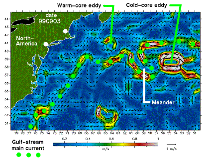 AN EXAMPLE OF FEATURES DISCERNIBLE USING SATELLITE
ALTIMETRY
AN EXAMPLE OF FEATURES DISCERNIBLE USING SATELLITE
ALTIMETRY
Applications of Satellite Altimetry Data:
-
Derived Products: Wind Speed; Wave Height; Dynamic Sea Surface Height
-
Model Assimilation: Altimetry data is converted to a temperature profile and
used for the Analysis Fields
in the Parallel Ocean Program
(POP) model; Some work being done to accomplish direct simulation.
-
Naval Oceanographic Office: Ocean Bogus (Fronts and Eddies); Digitized Fronts ≠
used for overlays of
altimeter tracks to infer positions of fronts and eddies;
Used for comparison with IR satellite imagery to
deduce the existence of weak
fronts at depth.
References:
http://www.deos.tudelft.nl/altim/altim.html
http://www.deos.tudelft.nl/altim/gulfstream/info.shtml
http://www.deos.tudelft.nl/general/topics/geosat.shtml
http://www.deos.tudelft.nl/general/topics/topex.shtml
http://ftp.csr.utexas.edu/sst/sla.html
http://topex-www.jpl.nasa.gov/mission/mission.html
http://topex-www.jpl.nasa.gov/mission/jason-fact-sheet.html
http://www.deos.tudelft.nl/altim/gulfstream/#07
http://www.deos.tudelft.nl/ers/instruments.html