SYNOP - Recent Observations of the Gulf Stream
LCDR Henry A. Miller, USN
The Gulf Stream was first described by Ponce de Leon in the early sixteenth century. Benjamin Franklin, as U.S. Postmaster General, produced the first chart of the Gulf Stream in the late eighteenth century. In 1844, the U.S. Coast and Geodetic Survey began the first systematic survey of the current. Since then numerous studies have sought to understand the structure and dynamics of the Gulf Stream. The latest was the Synoptic Ocean Prediction (SYNOP) experiment from 1987 to 1990.
The Gulf Stream lies near the continental shelf break along the east coast from Florida up to Cape Hatteras, NC. It actually exhibits a bimodal pattern in this region. It lies either right along the shelf break with very small meanders or a bit offshore of the shelf break with larger meanders. After Cape Hatteras, the Stream separates from the coast and extends into the Atlantic as a free inertial jet. In this region, there is a great deal of variability in its location, and the meanders form very strong mesoscale eddies called Gulf Stream rings.
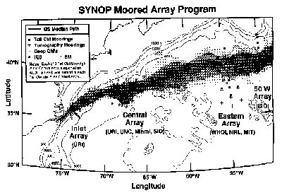
The SYNOP experiment consisted of three arrays of moored current meters, bottom-mounted inverted echo sounders, and acoustic Doppler current profilers (ADCP) which were concentrated near Cape Hatteras, around 68W, and around 55W. The papers considered in this report primarily used data collected by the central array at 68W (Watts, et. al., 1995). The figure below shows the locations of sensors in the SYNOP experiment.
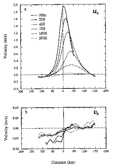 |
The stream coordinates averaging method was used to determine
the average velocity and transport of the
Gulf Stream. In this method, the coordinates are rotated to the downstream and cross-stream directions. In this way, as more accurate average is obtained because the location of the current is so variable. In simple Eulerian averaging, simply taking the average value at discrete geographic points over time, velocities may be averaged in when the Gulf Stream is not even in that location (Johns, et. al., 1995). The average near-surface, 50 m, maximum downstream velocity was found to be about 2 m/s. This maximum was shifted about 5 km offshore of the center of the stream due to a subsurface tongue of warm water increasing thermal wind in that area. A near constant 4-5 cm/s flow was found at a depth of 3500 m, which is not at all obvious from Eulerian averages (Johns, et. al., 1995). Cross-stream velocities, shown in the lower figure at left, also showed a significant inflow from the north which had not been noted in Eulerian averaged studies (Johns, et. al., 1995). The transport was determined to be 112.8 Sv at 68W. From previous stream-averaged studies, tranports of 93.7 Sv at 73W, 147 Sv at 60W, and 149 Sv at 54W had been determined. These measurements show an 8 Sv/100 km increase in transport between Cape Hatteras and 68W, and a 4.5 Sv/100 km increase between 68W and 54W (Johns, et. al., 1995). A westward transport of 16.6 Sv was also discovered north of the Gulf Stream. The exact reasons for this are not clear, but it is likely to be part of a cyclonic gyre over the slope water region due to positive wind stress curl north of the Gulf Stream. This northern recirculation contradicts earlier studies which reported that the only significant recirculation occurred to the south of the main current (Johns, et. al., 1995). |
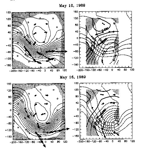
| Strong coupling was found between upper level steep meanders
and 3500m deep cyclones and anticyclones. For this purpose, steep
means amplitude greater than one-half wavelength. The mean flow at
3500m was about 0.05 m/s, but could reach 0.4 m/s during these steep meander
events. This flow is much stronger than previously noted at such
depth (Shay, et. al., 1995).
The deep flow is not a simple extension of the Gulf Stream. The previously help "deep Gulf Stream" model is an oversimplification. A strong cross-stream component of the deep velocity was frequently noted and could actually be perpendicular to the Gulf Stream during the steep meander events. Upper level steep meander troughs were accompanied by deep cyclones and steep meander crests were accompanied by deep anticyclones (Johns, et. al., 1995). The region around 68W seemed to be predisposed to the formation of steep meander troughs. Bathymetry may play some role. Additionally, interaction with the downstream mesoscale eddy field is important. As progress of meander is impeded by the downstream eddy, its amplitude grows (Johns, et. al., 1995). |
 |
Johns, W. E., T. J. Shay, J. M. Bane, and D. R. Watts, 1995: Gulf Stream structure, transport, and recirculation near 68W. J. Geophys. Res., 100, 817-838.
Shay, T. J., J. M. Bane, D. R. Watts, and K. L. Tracey, 1995: Gulf Stream flow field and events near 68W. J. Geophys. Res., 100, 22,565-22,589.
Watts, D. R., K. L. Tracey, J. M. Bane, and T. J. Shay, 1995: Gulf Stream path and thermocline structure near 74W and 68W. J. Geophys. Res., 100, 18,291-18,312.
Other Resources
Carolina Coastal University
nCSU Long Beach, Dept of Geological Sciences
New Jersey Network Infrastructure in Education Project
nEncyclopedia Britannica
The Sea, Robinson and Brink
Goddard Space Flight Center, NASA
nNaval Oceanographic Office
| This is a government-maintained internet site. Please read the U.S. Navy web page disclaimerand the dislaimer regarding external links. |