Topic Area
Currents and Eddies in the Persian Gulf
Project Team Member(s)
LCDR Marc C. Eckardt, USN
Major Findings
The Arabian Marginal Seas and Gulfs are predominantly forced by the
Arabian Monsoon. The combined effects of both air mass changes and wind
lead to interesting and complex mesoscale variations within these littoral
regions. The Arabian Sea and Gulf of Oman are largely affected by Monsoon
wind patterns, evident by the Equatorial Counter Current disappearing during
the summer monsoon; however, the Persian Gulf is relatively unaffected
by these wind changes due to topographic shielding and instead can be characterized
by high evaporation rates and a thermo-haline circulation.
The Persian Gulf circulation can be broken into three main areas:
-
Northern - this region is dominated by consistent wind driven transport
to the south, which creates upwelling on the Iranian coast and down welling
on the Saudi coast. Freshwater river runoff has a small impact on the circulation
and can be seen by the river plume that remains to the south.
-
Southern - this region is separated from the North by a temperature and
salinity front. Inflow from the Straits in conjunction with down welling
and areas of intense evaporation (> 40psu) create a permanent cyclonic
gyre in the central Gulf. This heavier water sinks and is forced back out
of the straits at an equilibrium depth.
-
Eastern - the Strait of Hormuz has a very small sill and thus a classic
inverse-estuarine circulation dominates the Gulf. Relatively freshwater
flows in through the Straits and the more saline water flow uninhibited
out of the straits at depth.
Once through the straits, the heavier / saltier water strongly influences
the Gulf of Oman where cyclonic sub-mesoscale eddies (referred to as "Peddies")
are seen to form. The mechanism for the formation of Peddies is not well
understood but data from several cruises and satellite imagery support
the existence of these eddies. Farther downstream, the outflow of the Gulf
interacts with the northward flowing Oman coastal current to produce a
sharp front and associated eddies.
The dynamics of all of these processes are not well understood and data
for appropriate modeling is severely lacking. A consensus of researchers
is that a thorough environmental survey of the entire area, using Lagrangian
floaters as well as satellite imagery, would greatly enhance the global
knowledge of this region.
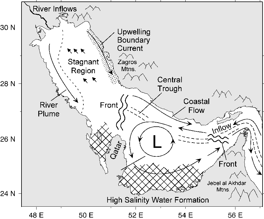
Figure 1. A synopsis of Persian Gulf circulation.
References
Johns, W. E., Jacobs, G. A., Kindle, J. C., Murray, S. P., Carron, M.,
1999: "Arabian Marginal Seas and Gulfs"
Univ of Miami RSMAS Technical
Report 2000-01., http://mpo.rsmas.miami.edu/~zantopp/AMSG-report.html
| This is a government-maintained internet site. Please read the U.S.
Navy web page disclaimer
and the dislaimer regarding external
links. |
|