 |
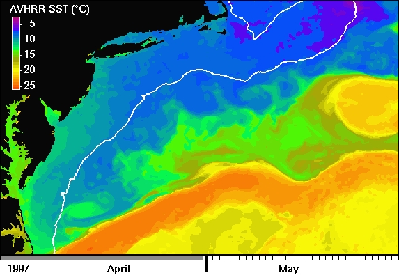
| The above image shows ocean sea surface temperature (SST) as observed by a satellite instrument (NOAA Advanced Very High Resolution Radiometer - AVHRR). >From this page, you can access animations of SST in this dynamic region. |
 |
| The above image shows ocean sea surface temperature (SST) as observed by a satellite instrument (NOAA Advanced Very High Resolution Radiometer - AVHRR). >From this page, you can access animations of SST in this dynamic region. |
The domain shown in the above image extends along the northeastern U.S. between approximately Cape Hatteras, North Carolina and Cape Cod, Massachusetts. Land is masked in black and SST is represented in color (scale at left of image). The white contour is the 100-m isobath, representing the continental shelf break; it also defines the perimeter of Georges Bank, east of Cape Cod. The continental shelf ocean between Cape Hatteras and Georges Bank is known as the Mid-Atlantic Bight (MAB).
It is in the MAB that the Gulf Stream (the band of warmest water oriented SW-NE) separates from the continental shelf and develops large meanders. These meanders can become so steep that they close upon themselves to form eddies. Anticyclonic (clockwise spinning) eddies that form north of the stream are called warm-core rings (WCRs). WCRs translate W-SW along the continental slope until absorbed by the Gulf Stream. In the above image, there are two WCRs. In the animation, you will see the more southern WCR absorbed by the Gulf Stream north of Cape Hatteras. The more northern WCR displays a series of interactions with the Gulf Stream and continental shelf waters, being forced up against the shelfbreak of Georges Bank by a Gulf Stream meander and drawing large filaments of cold shelf water into the Slope Sea.
Entrainment of shelf water by WCRs is associated with enhancement of chlorophyll along the continental shelfbreak. For more information on this annual, late-spring ecological development, please see Ryan et al. (1999a). Structure and processes of a spectacular occurence are detailed in Ryan et al. (2000). Georges Bank is a very important region, ecologically and economically. It has supported New England fisherman for a very long time, but overfishing has significantly depleted this valuable resource. For more information about ongoing study of the ecology and physical-biological coupling of this important region, visit the U.S. GLOBEC Georges Bank program.
This SST animation also illustrates meanders of the shelfbreak (shelf-slope) front. This front outcrops at the surface tens to ~100 km seaward of the shelfbreak and is visible in SST. Notice the convoluted boundary between temperatures represented by blue and green (~ 10°C), between the 2 WCRs. In the animation, you will see these frontal meanders distort and exchange waters across the front as they propagate W-SW. These meanders were associated with strong chlorophyll enhancement at the continental shelfbreak. The mechanism of chlorophyll enhancement was upwelling shelf waters along isopycnals of the front, forced by meander circulation along the shelfbreak. For more information, please see Ryan et al. (1999b). For more information on ecological insight from study of physical processes and optical properties in coastal waters, visit the Coastal Mixing and Optics program.
Watch as ocean circulation comes to life...