A Short Overview of Differential GPS
James R. Clynch
Naval Postgraduate School
December 2001
The Global Positioning System delivers about 6 m horizontal error and 10 m in three dimensions to a dual frequency user. This was much worse for the civilian user before the intentional degradation of the signal was removed. It likely will improve in the future.
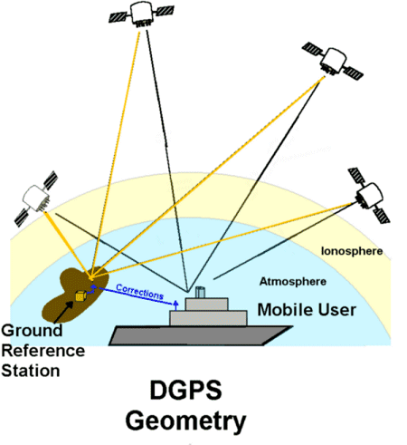
Differential GPS works by having a reference system at a known location measure the errors in the signals and send corrections to users in the "local" area. These corrections will not be universal, but will be useful over a significant area. The corrections are normally sent every few seconds. The user is generally some mobile platform such as a ship, car, truck or even an aircraft.
Figure 1
For the majority of civilian users single frequency receivers are used. The public ranging modulation is currently only on the L1 signal. The only ranging signal on L2 is encrypted. The exceptions are survey and scientific systems that use expensive receivers with methods to work around the L2 encryption. The single frequency user must deal with the error produced as the signals go through the ionosphere. The second frequency was put on the GPS satellites to allow real time removal of the ionospheric error. It does this to an accuracy better than 1 cm.
The use of differential GPS produces a position solution much more accurate than the that of the standalone user, either civilian or military. It does this even for the single frequency receivers. In fact all common DGPS systems work only with the L1 frequency signal, even if the receiver can track both L1 and L2 frequencies. It is common today to have ships navigating on DGPS with 1 to 2 meter position accuracy.
This note will address the broad topics that lead to the GPS errors, how DGPS corrects for them, the different DGPS techniques and philosophies.
Differential GPS works by measuring the errors in GPS signals at a reference station(s) and sending the corrections to users. The errors in the signal at then antenna should be almost the same for another receiver close by. The definition of "close" depends on the specific error.
A diagram of the errors in a GPS range measurement is shown in Figure 2. The true range, on the top line, is the value needed for navigation. It is between 20,000 and 40,000 km. The other large value on that line, the receiver clock error, is estimated each time a solution is performed. It can be thousands of kilometers in some receivers. The estimation of the receiver clock error is usually is done each time a new solution is done in a navigation receiver commonly every second. The "other" item on the top line is expanded below. It is only a few 10s of meters at most.
The Selective Availability (SA), when it was turned on, had a standard deviation of about 30 meters. It was usually the dominant error for the civilian GPS user. It is zero now. However, when it was on, it was totally removed by DGPS systems.
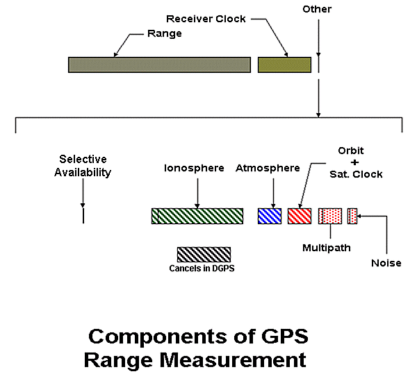
Figure 2
The ionosphere error varies greatly with time of day, location, and the solar cycle. It also is a function of elevation angle. Low elevation angle lines of sight have a longer path length within the ionosphere than vertical paths. At night for high elevation angles the ionospheric error can be as low as 1 meter. In late afternoon, in the tropics, at solar maximum, a 20 degree elevation angle observation could have a 50 m ionospheric error. Ionosphere errors in the tropics at the 10 to 30 m level are common.
The atmospheric error is about 2.5 m for a vertical line of sight. It varies in a very predictable way and is well modeled in most receivers. Only at angles below 5 degrees do complex bending effects come into play. Only very precise scientific work needs to go beyond the standard modeling for this error. The ionosphere is the dominant error for single frequency user. The last three errors are the dominant error sources for a dual frequency user. They are also important for the single frequency user.
In order to navigate, not only are good ranges needed, but also the location of the end point of the range. That is, the positions of the satellites are required. Providing this information is the job of the US Air Force, which runs the GPS system. They use a series of monitor stations to acquire data in real time and estimate the position, velocity, and satellite clock error of each satellite every 15 minutes. They use these solutions to make a prediction of the satellite parameters for the following day. These predictions are then parameterized and loaded into the satellite onboard memory. This data is sent to the user on the GPS signal. It is called the Broadcast Ephemeris (BCE). On average this prediction will be 12 hours old.
The largest error will be the satellite clock error. If all the satellite clocks are not synchronized, navigation is degraded. Setting all the GPS satellite clocks to a form of Universal Time Coordinated (UTC) accomplishes this. (The time differs from UTC by some integer number of seconds. For this reason it is called GPS Time.) Even though extremely good atomic clocks are on each satellite, there is a wander in the clocks. This is a random process and cannot be modeled. There may also be some residual systematic error in the predicted clock state.
All these errors, which are marked with a diagonal bar in Figure 2, are the same for close receivers. These are the errors that are removed in DGPS systems.
There are two remaining errors that are specific to individual receivers. The multipath error is caused by reflections of the GPS signals from metal objects near the antenna. DGPS reference stations go to great lengths to minimize this error though good antenna locations. The DGPS user may not have this option. The last error is the thermal noise inside the receiver. This is a function of the individual receiver design. It is lower in more expensive receivers. However each year the receiver noise level on new receivers decreases some. It is like the increase in speed on computers, but not quite as dramatic a change. Today the receiver noise varies from 2 m to 10 cm for civilian receivers.
Today the ionosphere and Orbit-and-Clock errors are usually the dominant errors for the civilian navigator. DGPS essentially removes these. The orbit error is only slightly different for users within a 1000 km or so of the reference station. That cannot be said of the ionosphere error. Its change with distance from the reference station is discussed later under ionospheric divergence.
The remaining issues in designing or choosing a DGPS system are how to get the errors to the user, and what solution technique to use.
There are two approaches to parameterizing the errors measured by the reference station(s). In the most common approach, the range error is measured for each satellite and these satellite by satellite errors sent to the user. This is a point approach. It is valid at the reference receiver. Its validity will decrease with distance from that site.
In the second approach multiple stations are used to estimate the errors over an extended area. This is called Wide Area DGPS (WADGPS). The Federal Aviation Administrations (FAA) Wide Area Augmentation System (WAAS) is this type of system. There are also commercial systems of this type. The corrections are parameterized in a way that allows the user to compute corrections based on his location. Two users separated by a 100 km or so will get different corrections from the same WADGPS parameter set.
In both these cases the information volume is quite small. A few hundred bytes contain one set of corrections for all the satellites in an area. The corrections are sent at different rates by different systems. Six second updates are common. The more accurate systems use one second updates. This is still a very low data rate. Note that distribution of the corrections is just a communication problem.
Standard DGPS systems normally distribute the corrections to the user over a radio link. The US Coast Guard has an existing system of directional radio beacons in the 275 to 325 kHz band. It chose to modulate the DGPS corrections from its reference stations on these signals. If it were not for ionospheric divergence (see below) the only limitation on the use of the US Coast Guard DGPS signals would the range at which these radio beacons can be received. A map showing the USCG West Coast sites, the broadcast frequencies, and their official coverage areas is shown in Figure 3. The original USCG system covered the West Coast, the East Coast, the Gulf Coast, the Great Lakes, and the Mississippi River. As seen on the map, new inland sites are now being added to the system.
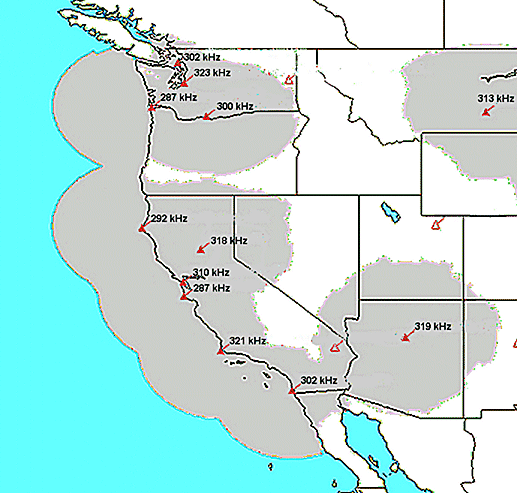
Figure 3
The FAA uses a geostationary satellite to broadcast the WAAS corrections. The satellite has a transponder and just retransmits a signal originating on the ground. This same approach is used by at least one commercial service that provides WADGPS.
Some other commercial services put the data on a sub-carrier on FM radio broadcasts. For science and surveying applications, a special radio link is often set up. This is usually done when a dedicated reference site is installed for a particular survey or science study or campaign. There are also experimental systems that deliver the corrections over the Internet.
The format of the correction information varies. There are now two public formats, the RTCM-104 and the WAAS. The RTCM or Radio TeleCommunications, Marine, is a standards organization. The format was generated by its special committee number 104. The WAAS was designed by a similar industry/government organization, the RTCA. In addition many manufactures of high end equipment have a proprietary format. The manufacturers formats are often aimed at the more precise DGPS method called Kinematics.
The RTCM format was adopted by the US Coast Guard. This has lead to its wide acceptance. Essentially all receivers that do DGPS positioning accept RTCM-104 as one of their input formats. The FAAs WAAS format has been standardized more recently. However, because the signal is available thought out North America on a free basis, it is being incorporated into many receivers. (The WAAS is currently in a test and evaluation phase.) The WAAS format is mandated for use in aircraft, but boat, car and handheld GPS receivers are available that use it. This format has more error checking than the RTCM format because it is designed for a "safety of life" function.
In most cases, a separate receiver is used to receive the DGPS corrections. These are then feed to the GPS receiver over a RS232 serial line. With this architure, the corrections could come from any of several sources. In some instances multiple sources are on ships and a simple switch is used to change between sources. In other cases standard sources (such as the US Coast Guard) are received at some convenient location and relayed by other means, such as cell telephone or VHF/UHF radio links, to the user.
The normal limitation on the utility of DGPS corrections is the difference in the ionospheric error seen by the reference station and the user. This ionospheric error is determined by the ionospheric conditions where the line of sight passes through 300 to 400 km altitude. For a vertical ray, this is overhead. For a low elevation ray it can be 1500 km away (about 15 degrees of earth central angle).
The ionosphere is much more variable than the atmosphere. It most dramatic variation is from day to night. It essentially goes away late at night. It rebuilds quickly at dawn and then intensifies thought the day. Its decay after sunset is gradual. Maps of the peak electron density of the ionosphere are shown in Figures 4 and 5. These values are proportional to the ionospheric error. The plots are for 1800 UT, when sunrise is in the Pacific and sunset over the zero of longitude line. Sunrise at 300 km occurs before it does on the ground.
'
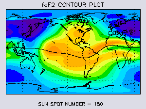
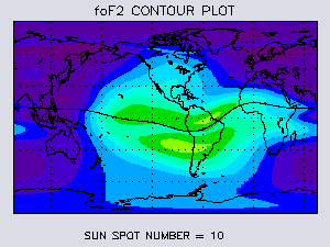
Figure 4 Figure 5
The data in Figure 4 is for solar maximum. This occurred in 2000-2001 for the current solar cycle. The solar cycle is about 11 years long. Therefore the next minimum should occur in 2006.
The two humps during the day are caused by the magnetic field of the earth. The peaks are about 12 degrees north and south of the geomagnetic equator, which is shown as a line on these plots. The precise location of these "equatorial anomalies" can vary from day to day. These figures are analogous to climate models, not weather data.
The spatial gradients on the sides of these peaks will be where the largest spatial divergences in DGPS signals occur. There are also large gradients a dawn. Note that satellites to the south at 20 degrees elevation angle seen from the extreme southern US will be seen though this gradient on some days. Sites nearer the equator will experience this more often and at higher elevation angles.
There are two common methods of finding a location with differential GPS. The most common method for navigation applications is to use corrected ranges. This is the same solution method used by the standalone user, but with some systematic errors removed.
The survey community has used the carrier phase as its basic measurement from the beginning of GPS surveying. This was then applied to cases where the unknown location was in motion. This was called Kinematics. In practice kinematics can only be done with dual frequency data. Even though both frequencies are used, it is sensitive to ionospheric divergence. The user usually needs to be within 30 km of the reference site during the day.
In the beginning, kinematics was only done on a post-processing basis. However with the increase in computation capabilities, it became possible to do the kinematic solution inside the GPS receiver. This is called Real Time Kinematics, or RTK. Many high end dual frequency receivers now can do RTK. It is still limited to ranges of 30 to 100 km of the reference sites. Also the system often needs to be initialized at 30 km or less.
The original version of the RTCM format did not allow for the corrections necessary for RTK. However, revision 2 has new message formats designed for this. Many RTK implementations allow both the RTCM and manufacturer proprietary DGPS formats.
The package of changes that was accepted when the Selective Availability was turned off includes two other items important to civilian DGPS users. First the publicly available ranging signal will be placed on both the GPS frequencies beginning with launches in 2003. The earlier spacecraft only had this signal on the L1 frequency. This will make it possible for low end receivers now to automatically correct for the ionospheric error. Using the L2 signal in DGPS will require some changes to the RTCM format, but this is expected.
Beginning in about 2007, satellites launched will have a third civilian frequency, called L5. This will allow kinematic solutions to be initialized and utilized at much longer ranges. The precise ranges will have to be determined post launch. It is likely that WAAS will not utilize the new signal on L2, but it is likely to use the L5 signal. This is due to a low, but measurable, probability of interference on L2 with some radars and mobile communications services in Europe.
There are many science experiments done each year using GPS. Some, for example from NASAs Goddard Space Flight Center, have done kinematics out to a thousand kilometers. Experiments have been conducted on using a network of reference stations to generate standard GPS corrections. Receivers are becoming immune to multipath, at least for the top of the line receivers. The noise level in receivers is also coming down. Where all this will lead is unclear, but the results can only be beneficial to the GPS community.