


Latitude and Longitude in the Real World
Latitude Types
The two common latitudes used by the public and in science are the geocentric
latitude,
![]() ,
and geodetic latitude
,
and geodetic latitude
![]() .
The geocentric is what one defines in elementary
textbooks that take the world to be a sphere. It is drawn from the surface to
the center of the earth. This is not what is printed on maps. Maps use
geodetic or geographic latitude.
.
The geocentric is what one defines in elementary
textbooks that take the world to be a sphere. It is drawn from the surface to
the center of the earth. This is not what is printed on maps. Maps use
geodetic or geographic latitude.
The figure below shows a cross section of the ellipsoid. The vertical line is the polar axis. The solid horizontal line is in the equator. The dashed horizontal line is parallel to the equator at the intersection of the up-down line with the polar axis. The geodetic latitude occurs at both these lines.
The line parallel to the equator from the point on the surface also forms an angle of the geodetic latitude. This comes from the geometry theorem on opposite angles on a line intersecting two parallel lines.
The distance along the upper parallel line, called "p" here, is the distance from the point to the rotation axis. This will be a very important distance in computing the rotational effects.
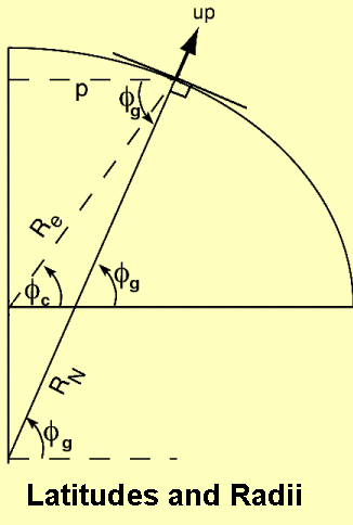
On this figure we see both the geodetic and geocentric latitudes. In addition there are two radii, the radius to the center of the earth, and the extended down line. This radius, Rn, is called the radius in the prime vertical. It is used to convert longitude angular differences into distances.
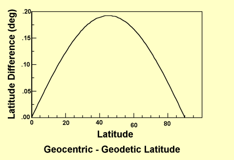
Some of the facts that can be seen from this plot:
The geocentric latitude is used extensively in satellite work. It is also used in the expansion of the gravity field in spherical harmonics. Otherwise, it is not used much.
The difference between the two latitudes is about 0.19 deg ( 11.5' ). This may seem small, but the radius of the earth is large and the maximum difference represents 21 km on the ground.
|
|
||||
|
|
|
|
|
|