


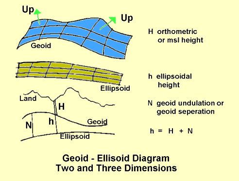
Heights - Two References, Two Types
Because there are two possible height references, there are two types of height. The heights measured by classical surveying are commonly called mean sea level (msl) heights. Offically heights referenced to the geoid are called orthometric heights.
Satellites systems directly measure X-Y-Z earth fixed Cartesian coordiantes. These are converted to height using the ellipsoid as a reference with no loss of accuracy. These heights are called ellipsoidal heights. They are also called geoidetic height in some books.
The difference between these two height types is the difference in the two reference surfaces. This is a called the undulation of the vertical, or the undulation for short. This difference, from the ellipsoid to the geoid, is also called the geoid seperation. It can be both positive or negative. It is usualy given the symbol N.
The undulation is a function of location. The geoid is bumpy. In order to convert satellite based heights into orthometric (msl) heights found on maps, the undulation is needed. This is defined by the earth's gravity field. Only in the early 2000's is it becoming well enought measured to be able to use satellite heights for high quality mapping.
The two heights are usually called h and H.
If h is the ellipsoid or geodetic height, and
H is the msl or orthometric height, then
A diagram of these heights in both two and three dimensions follows. The "up" direction, perpendicular to the geoid, is also shown.
Now for the bad news. In a check of 8 text books and official reports, the convention for which height is capital H and which is small h is split 4 to 4.
|
|
||||
|
|
|
|
|
|