


Heights - The Three Surfaces
There are really three surfaces that come into heights, the surface of the land ( or the sea bottom ), the geoid, and the mathematical surface of the ellipsoid.
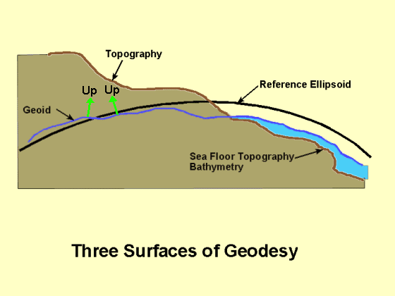
The land height is called topography and the sea bottom bathymetry. They are the height we want to determine. The two reference surfaces are the ellipsoid - which is smooth, and the geoid which is bumpy. Unfortunately it is the bumpy surface that we use when we do standard surveying.
The geoid is the surface of equal potential energy that matches the average level of the sea. Expressed in this way it's clear that the gravity field is critical to defining the geoid. Standing on the sea coast we can see the geoid, but not the ellipsoid. So we really don't know what the relation is between the two from direct observation. Because gravity is a long range force (you feel mountains on the other side of the world) it takes a lot of data. Until recently with a very large data bases of satellite measurements, neither the geoid or the earth's gravity field were well known.
The figure also shows that the "up" direction measured with a plumb bob or level is slightly different from the perpendicular to the ellipsoid. Up is the perpendicular to the geoid, not the ellipsoid. The magnitude of the difference is greatly exaggerate in the figure. It is usually a few arc seconds. ( An arc second is 1/3600 of a degree.) The angle between the gravity "up" and the perpendicular to the ellipsoid is called the deflection of the vertical.
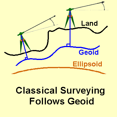
The reason the geoid is so is that it is the reference for all classical - non-satellite - height suverys. What we call mean sea level height uses the geoid as a reference because we use gravity to define up and the horizontal in these methods. While the deflection of the vertical is very small, this method of survey integrates these small effect from point to point.
|
|
||||
|
|
|
|
|
|