


Datums as Rubber Sheets
The different coordinates for the same point in different datums can often be significant. For example the difference between NAD 27 and NAD 83 can be over 100 meters (300 ft). In one case, that of the Tokyo Datum and the commonly used WGS 84 the difference is measured in kilometers or miles.
Over a small area the differences are usually just a constant offset in north and east. However over large areas, such as the United States, the error cannot be considered constant, even at the 10 m level. This is because the older surveys built up significant errors over long distances. Therefore these "difference" shown in table should only be taken as an order of magnitude for larger areas.
All older datums have distortions. These arise from the accumulation of survey errors. Over a small area, the difference between two datums is essentially an offset in north, east, and height. But this offset is not constant over large areas. For example, the NAD 27 datum has significant systematic distortions. The first good satellite based datum was World Geodetic System 1972 (WGS72) produced by the US Defense Department. The differences of NAD27 with respect to WGS72 clearly show these effects.
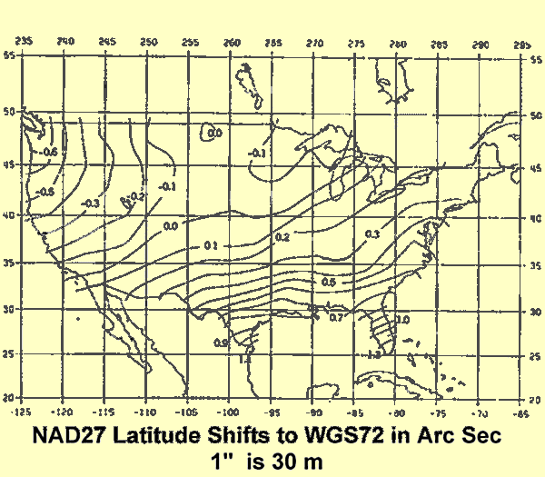
The latitude shift shows a progression from the northwest ( about –0.6” or -18 m ) to the southeast ( about 1.3” or 40 m). The difference in the shift is 60 meters. The difference in the longitude is larger.
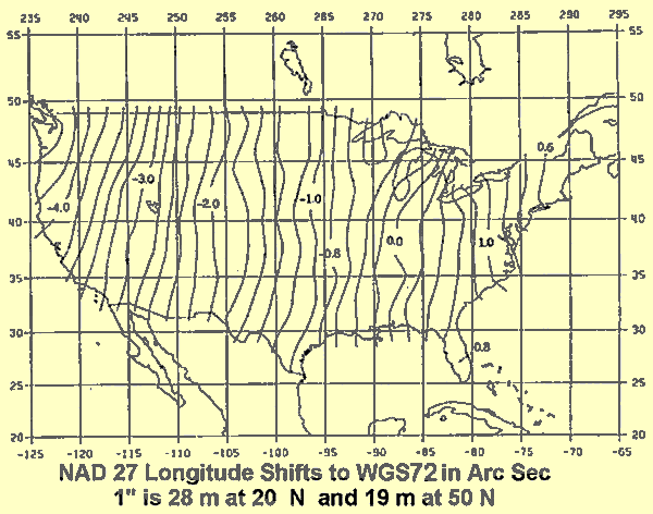
Here the difference is about 7.5”
and progress east to west. This has a distance magnitude from 140 to 210 m
depending on the latitude. Notice the rate of change picks up in the rocky
mountain area. There is a similar difference in the height, with the range
being -15 to –40 m.
|
|
||||
|
|
|
|
|
|