


Map Legends and Datums
If you examine the legend of a topographic map, it will list the datum use to generate it. On US Geodetic Survey maps this is in the lower left corner. Here is the corner of the map covering Monterey,CA. Notice that it says that the map is on NAD 83, but ...
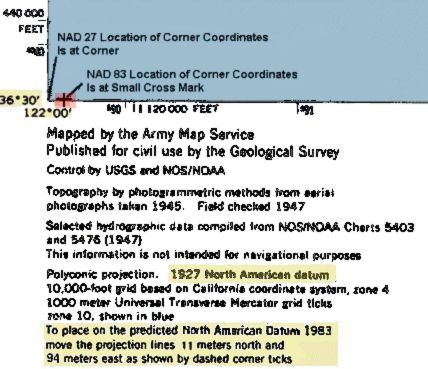
This is a example of an older map being updated using an overprinting. Many US topographic maps are the same as the NAD 27 maps with a notation in the legend on how to adjust the coordinates to NAD 83.Ā There is also often a small cross in the corner giving the location of the corner coordinates in the new datum.
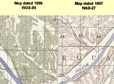
The different coordinates for the same point in different datums can often be significant.Ā For example the difference between NAD 27 and NAD 83 can be over 100 meters (300 ft) as it is here.Ā The following shows two small area (7.5 minute series) topographic maps from central Missouri. One is on the newer NAD83, the other still on NAD27. The maps have been cut and aligned with by the features. Notice that the coordiantes are now off. The difference is about 20 m in the North/South and 210 m East/West.
Datum shifts can be very large. In one case, that of the Tokyo Datum and the commonly used World Geodetic System 1984 (WGS84) the difference is measured in kilometers or miles.
Because WGS 84 is so important today, a map of the difference between it and common local datums has been generated. The differences are color coded in bins to make it easier to use. WGS84 is the default datum for most GPS receivers. Clearly in some areas of the world, you would be way off using this setting with a locally generated map.
|
|
||||
|
|
|
|
|
|