


Azimuth - Magnetic Variation
The most common method of determining heading or azimuth is with a compass. This really measures the horizontal component of the earth's magnetic field. This is almost the field of a bar magnet, but the magnet is not exactly aligned with the polar axis of the earth. It is tilted by about 12 degrees.
The difference between the true and magnetic headings is called the magnetic variation (or sometimes magnetic declination).
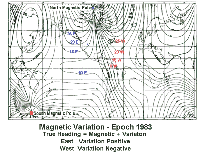
This plot of the variation is a reduced scale version of the official US NOAA chart. The location of the magnetic poles has been color coded to make them easier to identify. A few contour lines in each direction have also been labeled in color. There are four heavy lines of no variation. Everywhere else there is a significant adjustment to make to compass readings. Even on the equator variations can be as big as 15 degees.
|
|
||||
|
|
|
|
|
|