


Azimuth and Heading
Three are three basic methods used to measure azimuth. The most common is to use a compass. This measures the angle from the earth's magnetic field. Unfortunately the field does not always point north/south. In fact the variation from true north can be tens of degrees, especially in high latitudes.
The second method, used by surveyors, is the measure the angles with a theodolite using the line between two know points as a reference. The last measurement method is to use the stars as a reference. This is done in celestial navigation.
And of course you can use a map. But that gives the azimuth between two points on the map, and you have to identify them in the real world to use them.
A topographic map or a navigation chart has information about the offset of magnetic azimuth from true azimuth. Here is the little azimuth diagram from the topographic map of Monterey, CA.
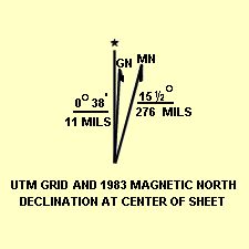
Notice that there are three lines. The one with the star is for true north. The MN line is magnetic north. The difference between magnetic and true north is called the "Variation" for ships. The topographic map calls this magnetic declination. (Ships use this term for something else.) For this map, the value is 15.5 degrees. It is east of true north, so the variation at Monterey is 15.5 deg E.
The rule is that you consider magnetic variations to be positive when they are "East" and negative when they are "West". This is the same convention used for longitude. Then:
This is the equation used to convert a compass heading to true heading.
The map also states that it is for the center of the map. This means that the value varies with location. Over a small area map, this will be insignificant.
Also, the values are nomally given to the nearest quarter of a degree. The variations are affected by local structures with iron in them and other things. Giving a value to more accuracy isn't meaningful. This is also true because the value is a function of time. And while the mean trends can be measured, they are a little unpredictable.
The GN north line is called Grid North. This is the up down line on the map. While this is nominally north-south, it is affected by the method used to "project" the round earth on the flat paper. This is know quite accurately and us usually small. Here it is 38' or 38/60 degrees. The unit MIL stands for milli-radians. That is 1/1000 of a radian.
|
|
||||
|
|
|
|
|
|