
Definition: Assimilate
So - instead of having a purely mathematically evolving ocean, with external forcing, we are incorporating data into the mathematical simulated ocean. We are using assimilation techniques to make our modeled fields resemble the ocean circulation patterns observed (and measured) at a given time and place.
"The purpose of data assimilation is to provide better estimates than can be obtained by only the data or the model."
- Allan Robinson
EXAMPLES
A model simulation that represents the evolution of the ocean for a period of time in the past.
A model simulation that is attempting to represent the ocean's circulation for a time in the future.
Mesoscale processes such as eddies that are somewhat chaotic by nature.
Test(1) = A set of Temperature estimates made by model and evolved by math equations for time = 1
Tobs(1) = A set of Temperature measured in the real ocean at time = 1
This is assumed to be "Truth".
Difference = Tobs(1) - Test(1)
Test(2) = Tobs(1) + R*Difference + Math
where R includes
Note that assimilating temperature data will also cause also will cause U, V, Salinity, SSH to change indirectly.
Variational techniques are useful for dealing with large complex systems such as the ocean where local changes in some variables (eg. temperature) have many consequences for other quantities (eg. currents). In other words, the ocean is a complicated system, and "adjusting" one location's temperature may affect many other quantites. All these other things have to be considered when adjusting one parameter at one location. The goal is to minimize some measure of difference between the model and the data.
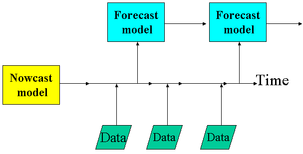
In the previous section, we made reference to the analysis - forecast cycle of data assimilation, whereby on a regular schedule, new data are quality-controlled, objectively analyzed in combination with a recent forecast field, the model is initialized, and a new short-term forecast is made. This type of intermittent data assimilation scheme works well for numerical weather prediction, where numerous observations over a large area are available on a preset schedule. This method is also used for some ocean models.
In continuous assimilation schemes, data is inserted whenever it becomes available. This has some advantages for the ocean, where in situ data is sparse and doesn't necessarily arrive on a regular schedule. Often, rather than inserting the data directly, incremental insertion is used, whereby the influence of new data is introduced gradually over time in order to minimize the imbalances that result from mismatches between the model and the data.
Another form of data assimilation used in the ocean is called nudging, whereby the model is gently pushed towards a known state over time.
Because the ocean in general evolves more slowly than the atmosphere, the window of time over which data is useful to a model is somewhat longer for the ocean than for the atmosphere. Data available within one to 24 hours might be considered "realtime", and data available within one to 10 days might be considered "semi-realtime". SSH and temperature are the variables most commonly assimilated into ocean models.
Sea Surface Height (SSH) anomalies
Sea Surface Temperatures (SST)
In Situ Temperatures
| surface drifters | surface | semi-realtime |
| Expendable Bathythermograph (XBT) | Temperatures in upper ocean | realtime to semi-realtime |
| Argo Floats - Global array of profiling floats | Temperatures/Salinities over upper 2000 m | 10-day cycle time |
| PALACE (Profiling Autonomous Lagrangian Circulation Explorer) Floats | upper 1000 m |
Other Measurements
| surface drifters | Surface velocities | At present, not commonly assimilated into models |
| Buoy measurements (for example TOGA/TAO array Pacific) U/V/T/S | various depths | semi-realtime |
A number of the above datasets are available through the Global Ocean Data Assimilation Experiment (www.usgodae.fnmoc.navy.mil).
(See http://meted.ucar.edu/nwp/pcu1/ic6/index.htm for some Comet material on data assimilation in atmospheric models.)
Now your model is designed and you've got data to force the model and data to assimilate into the model. But we're not quite done - we've got to find a computer system to run it on. Proceed to the "Implementation" section now.