Exercises and Scenarios
Objective: The following exercises are designed to help you become familiar with accessing Navy operational ocean circulation and tide model products through the NAVO and FNMOC NIPRNET web sites. You will gain experience in problem-solving and knowing which product to use for what problem through these scenarios.
Find all the ocean circulation and tide model products available from NAVO for your AOR. While there are more products available on the SIPRNET, a limited set of products may be found by clicking on Operational Products and Services on the NIPRNET site http://www.navo.navy.mil/, and then using Search by Form or Search by Map. Be sure to look at the Product-Info, as well as the Product.
Now go to FNMOC's site at http://www.fnmoc.navy.mil. You will need a username and password to obtain the highest level of access. Your command should be able to provide you with these. You can see the OTIS sea surface temperature under Oceanography. Only a few of the JMV thumbnail .dat files (and none of the .mct files) contain TOPS currents. You might look at the ones for your AOR and see if they are included.
Although it is not yet operational, you might want to check out some of the results from NCOM at http://www7320.nrlssc.navy.mil/global_ncom/index.html.
Now let's practice using some of these products in a search and rescue scenario. Since the available products change over time, it is not guaranteed that all the model products needed for this exercise will be available for the given location. If they are not available, you should pick another location.
A man went overboard off Colombia at 02o 30' N, 79o 30'W at 1700 GMT today. Do a drift projection for the next 48 hours using SDOM and WebSAR.
Does the WebSAR solution include the geostrophic currents? What circulation model is the SDOM drift project based on? Does it include tidal forcing? Look at MODAS for nowcast geostrophic currents. Why do you think they cut off at 2o N?
(Files from September 2002 are linked here to be used as a substitute if access to the real-time files is not possible. )
Four more hypothetical scenarios follow. In the course of preparing your answers to the questions posed with these, you should use all the following models at least once: ADCIRC, MODAS, NLOM, PCTides, SWAFS, and WebSAR.
- The carrier group Roosevelt will be transiting from Bermuda to Boston. They will be
trying out a new underwater communications system linking all the ships. They want
to monitor performance when all ships are on one side of the Gulf Stream or the
other, but especially when they're split across the Gulf Stream. The ships will leave
Bermuda at 0800 local time today. Assume their average speed over ground is 12 kts.
Estimate what time they will cross the Gulf Stream, and what the current speeds there
will be. Use the ship track on the figure provided (which commences at 1200 Z on
9/12/02 in this example). Are there any other features they will cross that might be of
acoustic interest?
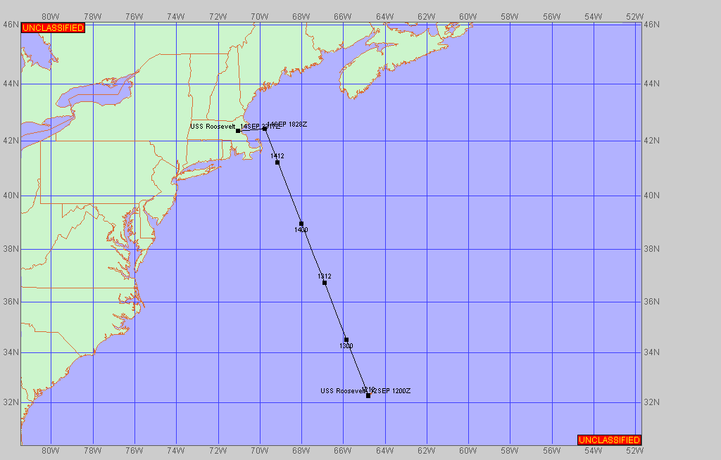
Hint: Don't forget that the ship departure time is given in local time.
If today's real-time files are not available, you can complete the exercise using this example model forecast from September 3, 2002.
- You are with a MET on a large-deck amphib. At 0600 this morning (pretend it's
September 6, 2002), a report was picked up that a fisherman is lost at sea. He
apparently fell overboard from a nearby ship sometime after 0300. The position of
the boat at that time was 36o 30' N, 150o 00' E.
A helicopter is dispatched to search for him.
The amphib is in EMCON condition (all communications are down, even
satellite); the distress report was picked up on a handheld radio.
The image below shows the
MODAS currents from the past few days (you've been looking at MODAS every
couple of days and saving them).
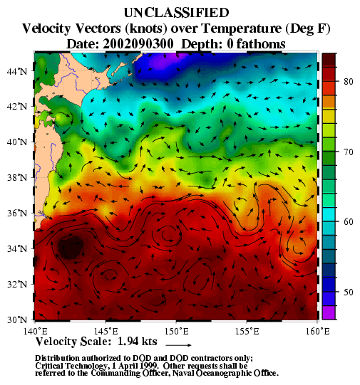
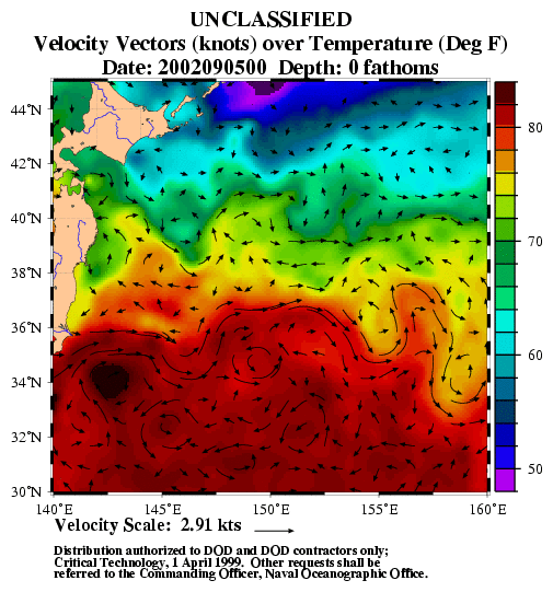
What guidance can you provide the search helicopter? The winds are 5 kts out of the southwest.
Now, assume the same scenario is happening in real time - today - and comms are working. Check the MODAS currents and compare them to other products and tools you have at your disposal for providing drift estimates. Do the MODAS currents include surface wind effects? Do the TOPS currents used in WebSAR include the geostrophic component of flow?
- During a Fleet Battle Exercise, a pallet was dropped in 20 m of water during a
resupply operation at 26oN, 35oE at 0200Z today.
A call comes in to the regional
METOC center requesting guidance on which way the pallet will drift over the next
10 hours given that it is neutrally buoyant.
Upon further questioning you find that the
pallet is expected to float at ~10 m depth. How would you proceed?
Referring to the model that you are using for guidance here; is there tidal forcing included in the solution? Is there wind forcing included? Is there much shear between the surface and 10 m? Do the currents change direction over the 10 hours?
(Files from September 2002 are linked here to be used as a substitute if access to the real-time files is not possible. )
-
You are working at the WSC (Warfighting Support Center) at NAVO when a request
comes in from SPECOPS for tidal current predictions in the Arabian Gulf at the
surface at 29o 54' 56" N, 48o 36' 04" E, for 24 and 72 hours from now; and also for
surface and 50 ft deep currents at 29o 30' N, 49o 00' E.
What can you provide? What
differences do you see between different products and what might these be due to?
Be sure to consider the limitations of the models and products including whether variations with depth are possible, the length of the forecast, and the temporal frequency of the output. When running PCTides, give careful consideration to where you put the boundary of the domain.
(Files from September 2002, linked here, can be used as a substitute to partially answer the above questions if access to PCTides and the real-time files is not possible.)