Synoptic Scale Refraction Effects


Learning Objectives


Introduction

The previous module concerned climatology and features that cover large areas of the earth’s globe. This module will look at processes on the smaller “synoptic” scale. In meteorology “synoptic scale” refers to features that are 200 to 2000 km in size. Cyclones (stormy low pressure areas) and anticyclones (sunny, high pressure areas) are examples of synoptic scale features. We'll take a look at midlatitude weather systems first and then tropical trade winds and monsoons.

Mid-Latitude Refraction


The diagram at right shows idealized locations of a polar high, a subtropical high, and a cyclone low with associated warm (red) and cold (blue fronts) in the Northern Hemisphere. These systems move west to east in mid-latitudes.

Next, we'll look individually at each part of these systems in terms of ducting. Below is a diagram similar to the schematic shown at right. In general, ducting is unlikely near the Low and the frontal regions. It is more likely in the high pressure areas.

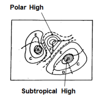
We'll look at each of the areas labeled A through F next in detail.

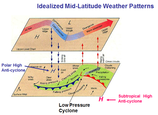
Image courtesy of Federation of American Scientists, http://www.fas.org/irp/imint/docs/rst/Sect14/baroclinic_schem_2p.jpg.


We will now look at the refractive conditions of features in tropical regions. Tropical regions are characterized by west-to-east moving weather systems. The doldrums is the rainy low pressure area near the equator, so named for the lack of wind in the area. The scientific name for the doldrums is the Inter-Tropical Convergence Zone (ITCZ). To the north and south of the doldrums lie the trade wind regions.

We discussed the subtropical high region (to 30o north or south latitude) in the previous module, but now we'll look at what's happening within that region on the synoptic scale.

Elevated inversions are common in trade wind regions. The diagram below shows how the inversion rises going from the subtropical high regions (left side) to the ITCZ near the equator (right side) where the inversion disappears altogether. As a result, the lower level clouds change from small and low cumulus with little vertical development in the subtropics to larger and deep cumulonimbus (thunderstorms) in the ITCZ. As would be expected from this inversion pattern, ducts are strong and low in the subtropical highs and get higher and weaker toward the equator. In the ITCZ there are no ducts (except for evaporation ducts).

Monsoon Regions

Ducting is common in monsoon source regions (upwind) and over ocean, but rare in rainy areas over land. Local effects are important in all tropical regions, especially over land and coastlines. Below we'll look at the Indian Ocean monsoon and the East Asian monsoon.

At left is a diagram of the wind patterns for the Indian Ocean Monsoon. In winter (left) ducting is most common where the wind just leaves land such as the west coast of India and Southeast Asia. In summer (right) ducting is most common off the East African Coast. In both situations as the wind blows over the ocean, moisture moves to upper levels and ducting becomes elevated and disappears after the air has traveled over the ocean for several thousand kilometers.
Another significant monsoon occurs in the East Asia Region. Ducting is generally not as common in this region as in the Indian Ocean monsoon area. This is because the upwind air masses do not originate over dry desert areas. The coastal areas of the island of Taiwan experience surface based ducts approximately 10% of the time throughout the year with a similar percentage of upper-level ducts. However just to the southwest in the South China Sea, ducting is much more common, with surface-based ducts occurring approximately 60% of the time in the summer months. During the winter months surface based ducts are not as common but elevated ducts occur frequently.