Back to the PIPS 3.0 Home PageModel Domain and BathymetrySample images and animations9 km Ice model improvementsThe 18 km Stand-alone sea ice model
The Navy's Polar Ice Prediction System 3.0 Upgrade

Regional Eddy Kinetic Energy Animations

These animations were generated from daily ocean snapshot files and monthly average files from Year 18 of spinup.  They are in .avi format and will play on xanim (Unix) or a windows media player. 

Annual mean surface velocity was calculated from 12 monthly average output files and also from 365 daily ocean snapshot files.  The values were within  + 0.04 cm/s, so the annual mean calculated from the monthly average files was used in all eddy kinetic energy (EKE) calculations. 
 

This distinction is made as the monthly average output files are 3D in temperature, salinity and velocity, whereas the daily snapshot files only contain surface velocity among other select variables.  Using the annual mean from monthly averages will allow calculation of EKE for layers other than the surface, although they will be monthly mean values. The daily EKE values show 4 to 6 times more variability than the monthly average values.
 

Daily values of u' and v' were then calculated by subtracting the annual mean surface velocity from the daily surface velocities.  Daily values of EKE were calculated as 1/2 the sum of the squares of u' and v'.

The approximate file sizes are listed - these are very large files, slow connections beware.  If you are having difficulty downloading the animations from this page, please contact us and we can set up an alternate means of getting you the animation.


Click on the picture for an image of the region, click on the link below for the animation
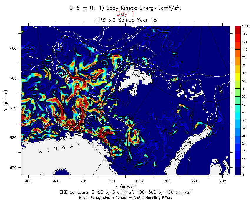
Barents Sea, Northern Norwegian Sea EKE
(55 Mb)
Click on the picture for an image of the region, click on the link below for the animation
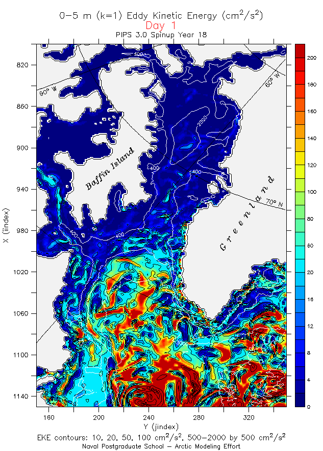
Labrador Sea, Baffin Bay EKE
(49 Mb)
Some interesting features to note:
  • Recirculation paths from the Norwegian Sea to the Greenland Sea
  • Summer increase in energy along the path of the Atlantic Water in the Barents Sea, particularly along the Eastern edge of St. Anna Trough.
  • "Geographically stable" areas of eddy activity - northwest of Frans Josef Land; in the vicinity of Nordkap, at the northen tip of Novaya Zemlya.
  • Every 5 to 7 days - pulses of energy transiting from left to right (west to east) - associated with synoptic scale weather events, easier to distinguish in the fall/winter.
Some interesting features to note:
  • Vigorous eddies traveling north then east along the bottom of the frame - associated with the North Atlantic Current.
  • Up to three separate paths of water from the East Greenland Current crossing the Labrador Sea between the 3000m and 400m curves.
  • West Greenland Current and Hudson Strait outflow intensifying in late summer and fall.
  • Distinct southerly flows on the shelf and deeper, along the western Labrador Sea shelf break.
Click on the picture for an image of the region, click on the link below for the animation
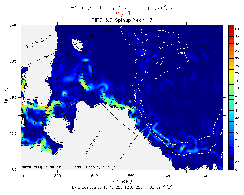
Chukchi Sea, Beaufort Sea EKE
(31 Mb)
Click on the picture for an image of the region, click on the link below for the animation
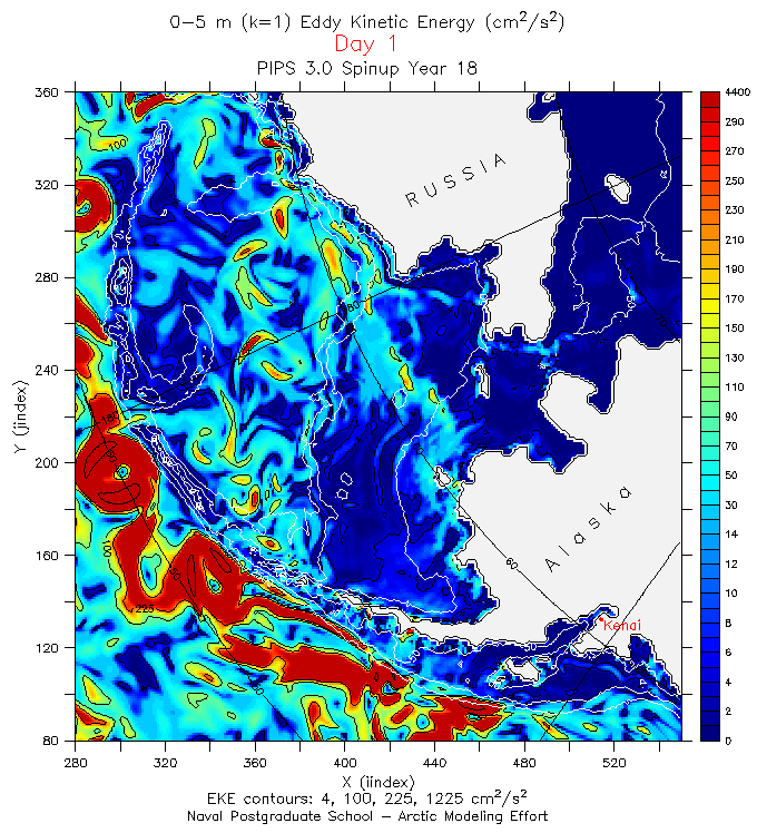
Bering Sea, Alaska Stream EKE 
(64 Mb)

back to the top


back to the PIPS  3.0 page

This is an official U.S. Navy Web site.

Privacy & Security Notice

NPS Disclaimer

External Links Disclaimer

U.S. Navy Important Links

Material contain herein is made available for the purpose of peer review and discussion
and does not necessarily reflect the views
of the Department of the Navy or the Department of Defense.


- Last modified 29 January 2003 -
Web site comments or questions? 
E-mail the Web Author