I. Introduction - What is GPS
The Global Positioning System, or GPS, is a satellite based navigation system developed by the United States Defense Department in the 1970's. It provides three items to users:
This is often abbreviated as PVT (Position/Velocity/Time). The system typically is delivering under 10 meter accuracy of position, under 10 cm/s velocities, and under 0.1 microsecond of time today to all users, military and civilian, to anyone with a $100 receiver.
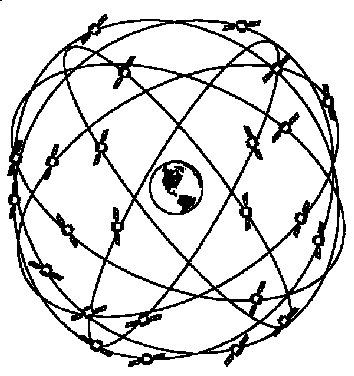
At the simplest level, it does this by having the antenna of a specialized radio receiver, a GPS receiver, open to the sky so that it can receive signals from 4 or more satellites. There are 28 active satellites in early 2003. The nominal constellation has 24 satellites, and the minimal system has 21.
The satellites are in high orbit at about 20,000 km above the earth in 6 orbital planes. They orbit the earth with a period of 12 hours. (This is 12 hours sidereal time.) The ground tracks repeat every day. This system ensures that more than 4 satellites are available everywhere on the earth at all times. This is a everywhere / anytime system.
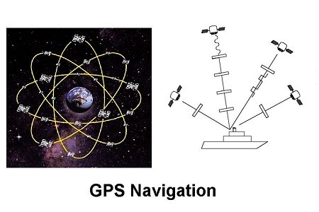
The generic navigation situation is shown above. The satellites broadcast signals that are received by the user. In this case a ship is shown. It could just as easily have been a truck, airplane, missile, surveyor, hiker, a bank ATM machine or many other types of users. The system is free to anyone with a GPS receiver. The number and type of users has grown over the two decades since the system as been operational. Currently the estimate is that there are over 5 billion dollars in annual sales of GPS equipment to civilian users. This is several times the military sales.
If GPS went away, it would cause major problems to both the military and civilian users. In a study conducted in 2000, it was shown that the most critical effects would come not from the loss of positions of velocities but from the loss of very accurate timing. The time accuracy available with GPS is under 1 microsecond. (In fact the error is usually on the order of 10 nanoseconds, although the specification is much higher.) This accuracy is over 3 orders of magnitude better than any other inexpensive methods. We have come to depend on synchronized time at remote locations for ATM's (encryption ), the power grid, and many other applications.
II. GPS Signals and PVT
The satellites broadcast a complex signal. It can be understood
as providing three effective signals, a carrier signal (sine
wave), a series of pulses, and some binary information modulated
on the signal. These are the "effective" signals seen in a
receiver after some signal processing. The details will be left
to engineering texts. (For those who want to know, the signals
are bi-phase modulated with two sequences of binary bits, on a
suppressed carrier signal. There is no carrier - why put energy
where it is not needed - and no pulses. The pulses and carrier
are generated in the receivers.)
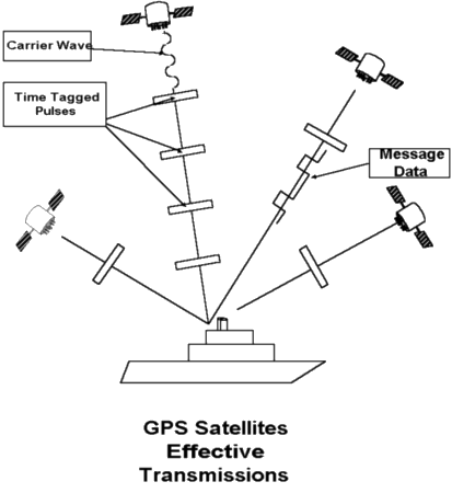
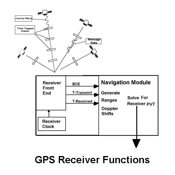
A diagram of the effective signals used by a GPS receiver is shown above. The signal generally used for navigation is a series of reconstructed pulses. These are tagged or labeled with the time of transmission by the satellites. The receiver notes the time that the pulse is received. The difference in time, multiplied by the speed of light, is the range to the satellite. GPS is a time of flight, pulsed timing system. It determines ranges using time of flight of effective pulses.
Of course there are many complications. The major one is that the receiver is using its own clock to tag the received time. This is often supplied by a very inexpensive crystal oscillator. The speed of light is about 0.3 meter per nanosecond ( about a foot per nanosecond). Thus very small errors in the receiver's clock can cause large range errors. This is solved by including the time bias of the receiver clock in the set of unknowns. Therefore there are 4 unknowns at each timeline where a solution is computed, 3 for position and 1 for time. This is why the minimum number of satellites for a solution is 4. It is also why the receiver can provide such good time. At each timeline, usually once per second, a new estimate of accurate time (GPS time) is generated in every receiver.
The second signal is the carrier wave. This is generally used to determine the velocity of the user. The frequency of the received signal will change if the receiver is moving. This is the Doppler shift. By measuring the Doppler frequency on at least 4 satellite signals, the three dimensional velocity and the frequency offset of the receiver's oscillator are found.
There are several issues that need to be considered in finding the position, velocity and time of the user from these measurements. The ranges are not useful in finding a position if you do not know the location of the other end of the range vector. The location of the satellites is needed. Telling the user about the location, velocity, and clock state of the satellite is the purpose of the third signal, the message data. This is a low rate binary signal at 50 bits per second. It provides a series of numbers that are used in a fixed set of equations (a model) to determine the satellites Position, Velocity, and Time. This information is divided into two pieces, called the Broadcast Ephemeris (BCE) and the Almanac.
It takes a maximum of 3 minutes tracking to get the BCE from a satellite. This data repeats every 3 minutes. The data from a satellite cannot be used for generating a solution until the BCE is completely received. The BCE changes very slowly, a new version is available once per hour. The BCE provides information on the satellite position and velocity, which is very accurate and stays that way for a day or so. The BCE also provides information about the bias of the satellites onboard clock. The satellites have an atomic clock, but it wanders a few nanoseconds per day. The inaccuracy in the clock parameters in the BCE are a major error source.
The message data from each satellite includes the high accuracy numbers for its own PVT. In order to help receivers plan satellite tracking an acquire satellites signals, a lower accuracy set of numbers is provided for all the satellites in orbit. This is called the Almanac. It cycles more slowly and takes 12.5 minutes to repeat. This data is updated weekly. Usually all satellites broadcast the same almanac. The almanac also contains some other parameters. Among these are the values needed to convert the GPS Time used by the satellites to Universal Time Coordinated (UTC).
III. Measurements to Positions
The GPS receiver can be though of as having 3 functional units:
These are shown on the diagram below.
In the early days of GPS receivers, the noise in the front end
was an important factor in the solution errors. Today the
errors in the BCE are often dominate. In some cases where there
is a lot of metal near the antenna, the measurement errors are
still important. This is called multipath.
The navigation module usually has a type of solution called a Kalman filter. This solution tries to keep a model of the receiver motion and solves for the difference between the predicted PVT and the values most consistent with the measurements. It forms a solution using weights for the new measurements and the past model. These weights are used to "forget" the data from the distant past that may not be relevant to the current position. (A ship, airplane or other vehicle is subject to unknown forces and the actions of the pilot.) These weights are often determined dynamically to adjust for the current receiver conditions. At turn on the solution often assumes it knows nothing but adjusts the weights to favor the model as it learns more.
One important distinction is between Measurement Space and Solution Space. There are different quality values published about the GPS satellites and the GPS system. Because the mapping between measurements and solutions takes place in every individual receiver, the GPS system quality values tend to be stated in terms of measurements - that is in measurement space. To the user, however, the errors in solutions are most important.
There is a very useful rule of thumb about the mapping between measurement errors and solution errors. This is stated in terms of a value called Dilution of Precision or DOP. The general rule is:
Dilution of Precision is always greater than 1. In using this you get a single value to quantify the solution error and must use some averaged measurement error.
DOP vary because the satellites are at different positions in the sky at different times. If all the satellites used in a solution are along a north-south line you have very good information on the north- south position, but poor information on east-west position. The DOP is a function of the geometry of the satellites used in the solution. If the satellites are well spread out in the sky, the DOP will be low. If the satellites are clustered, it will be high. (There are other conditions for high DOP that are harder to intuitively understand. After all the solution is done in a four dimensional space.)
There are several version of DOP's. The total solution, including the time has value called Geometric Dilution of Precision or GDOP. The position only case is called PDOP for Position Dilution of Precision. For the surface user, only horizontal position is usually important. This error is related to the average measurement error via HDOP. And there is also a time or TDOP.
IV. GPS Service Levels: Codes and Frequencies
There are two levels of service provided, the Standard Positioning Service (SPS) and the Precise Positioning Service (PPS). The PPS is defined as that functionality that needs encryption data and the SPS as any use that needs no encrypted data. In general this means the SPS is the civilian service and the PPS is the military service.
There is hardware on the satellites to provide two aspects that distinguish the two services, the Anti-Spoofing or AS function and the Selectivity Availability or SA function. The SA function degraded the accuracy of the solutions to a standalone user. It was essentially negated by Differential GPS. SA was turned off by presidential order in May 2000. It is unlikely to ever return.
Anti-Spoofing is designed to prevent an adversary from generating a signal that will be mistaken for a valid satellite signal. There are two different navigation codes used for generating the effective pulses, the CA or clear/acquisition code and the P/Y or precision code. The CA and P codes are public knowledge. The signal that is the P-code is encrypted by the AS function before it is transmitted. It is then re-labeled as the Y-code. The military uses receivers that accept cryptographic keys that allow the use of the Y-code. (These keys were also used to remove the SA effects.) By using only the Y-code in a conflict situation the possibility of spoofing a military receiver is essentially zero. There are other things an adversary can do however, such as jamming.
There are two frequencies broadcast by the GPS satellites. These are called the L1 at 1575 MHz and L2 at 1227 MHz. The L1 signal is thought of as the measurement signal. This measurement goes through the ionosphere, a region between about 100 and 1000 km above the earth. Passage through the ionosphere adds a systematic error to the ranges. However this error can be removed to the millimeter level using the L2 signal. This is the primary function of the L2 signal. The P/Y codes are on both frequencies. The CA , or civilian, signal is only on L1. Therefore civilian users would normally be effected by the ionospheric error.
The use of DGPS effectively illuminates this error over a significant area, out to 50 to 500 km depending of many factors. In addition the civilian receiver manufactures have developed several methods of tracing the L2 signal despite it being encrypted. (This does not affect the anti-spoofing value of the encryption so the military is not worried about this development.) This L2 tracking was previously available only on expensive receivers used for survey and other precision applications. It is becoming available on more inexpensive receivers now.
As part of the agreement that lead to the termination of the SA function, newer satellites will have a new broadcast frequency called L5. This signal is principally intended to remove the ionospheric error for the civilians. It will have an unencrypted range code.
The L2, and now L5, signals have been used for more than ionospheric corrections from the beginning. These are mainly for high accuracy applications. This will continue.
V. Segments
It is conventional to discuss the overall GPS system as being broken into three segments:
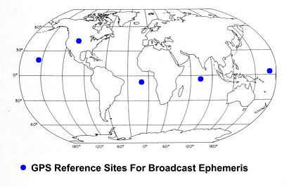
The control segment is the key to accuracy of the solution to a non-differential user. This occurs thorough the generation of the Broadcast Ephemeris. The Control Segment consists of 5 sties spread around the world. These sites have two functions. They have high quality PPS receivers that acquire data. Instead of being used to compute the position of the sites, the raw data is transmitted to a central site in Colorado Springs. This data is used to compute the new BCE's. These sites also have upload antennas that are used to send the BCE's to the satellites. The satellites just read the message data from an internal memory. All the computation is done on the ground and the bits transmitted sent in the uploads to the satellites.
VI. System Control and Administration.
The GPS system was begun in the early 1970's with the formation
of a Joint Program Office (the GPS-JPO) to oversea the
development of a joint services navigation system. It was the
merger of Air Force and Navy systems then being planned. The
management has evolved from a JPO to a multiple cabinet level
executive committee. The Air Force remains the lead agency and
the executive agent. The major players are now the
Position/Navigation committees of the Department of Defense and
Department of Transportation.
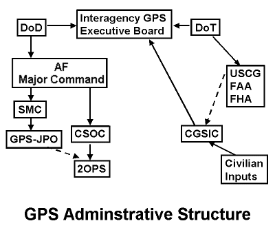
The structure is outlined in the figure above.
The Interagency GPS Executive Board (IGEB) has two co-chair members and several other members. The DoD and DoT are the ch-chairs. The departments of Commerce, Interior, State, Justice and Agriculture are also members as well as NASA and the Joint Chiefs of Staff of the DoD. The Air Force is the executive agent. It's efforts are all under a major US Air Force Command (formally the US Space Command before it was merged). The two major USAF players deal with daily operations and development. The Consolidated Satellite Operations Command Center (CSOC) is where the GPS day to day operations occur. The Second Operations Squadron (2OPS) at the CSOC handles GPS. All development and procurement of hardware and the management of software development is done by the GPS-JPO which is part of the Space and Missile Command (SMC) at Los Angeles Air Force Base.
The civilian inputs are channeled through a committee that has frequent public meetings. This is the Civilian GPS Service Interface Committee (CGSIC) . The US Coast Guard (USCG) serves as the agent that provides support to the CGSIC. Most civilian interface to the GPS system first occurs with the Coast Guard. They have a Navigation Center just outside Washington that provides an internet site for this purpose. ( www.navcen.uscg.gov ) . This site has current status of the satellites and the system as a whole, most public GPS documents and specifications as well as some forms for submitting comments or trouble reports. The minutes and agenda of the CGSIC are located at this Internet site.
|
Last Modified/Reviewed:
05 February 2003
|
| Material contained herein is made available for the purpose of peer review and discussion and does not necessarily reflect the views of the Department of the Navy or the Department of Defense. |
 James Clynch