
|
Geodesy for the Layman - Table of Contents |
A datum is defined as any numerical or geometrical quantity or set of such quantities which serve as a reference or base for other quantities. In geodesy two types of datums must be considered: a horizontal datum which forms the basis for the computations of horizontal control surveys in which the curvature of the earth is considered, and a vertical datum to which elevations are referred. In other words, the coordinates for points in specific geodetic surveys and triangulation networks are computed from certain initial quantities (datums).
A horizontal geodetic datum may consist of the longitude and latitude of an initial point (origin); an azimuth of a line (direction) to some other triangulation station; the parameters (radius and flattening) of the ellipsoid selected for the computations; and the geoid separation at the origin. A change in any of these quantities affects every point on the datum. For this reason, while positions within a system are directly and accurately relatable, data such as distance and azimuth derived from computations involving geodetic positions on different datums will be in error in proportion to the difference in the initial quantities.
Orientation of Ellipsoid to Geoid
Single Astronomic Position Datum Orientation
Selection of the reference ellipsoid provides the radius and flattening factors. The simplest means of obtaining the other factors to establish the geodetic datum is to select a station, preferably one located near the center of a triangulation network, to serve as the datum origin. Then the astronomical coordinates of the station and the astronomical azimuth of a line from the station to another control station are observed. The observed astronomical coordinates and azimuth are adopted without any correction as the geodetic coordinates and azimuth of the datum origin on the reference ellipsoid. Further, the geoid and ellipsoid are assumed to coincide at that point. This means that the deflection of the vertical and the separation between the ellipsoid and geoid are defined as zero at the origin. By using this method of orientation, the normal to the ellipsoid is arbitrarily made to coincide with the plumb line at the datum origin. Figure 15.
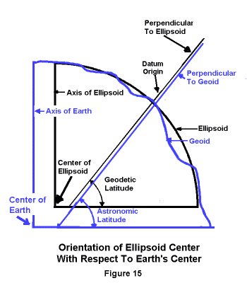
FIGURE 15 SINGLE ASTRONOMICAL STATION DATUM ORIENTATION
Although the computed positions will be correct with respect to each other in this type of orientation, the entire net will be shifted with respect to the axis of the earth. This is not significant for local use of the positions but may introduce large systematic errors as the survey is expanded.
It should be noted that although the deflection and undulation are defined as zero at the origin, deflections will occur at other positions within the network. When comparing the geodetic latitude and longitude of any other point in the net with the corresponding astronomical latitude and longitude of that point, differences will appear between the two sets of values.
A datum oriented by a single astronomical point may produce large systematic geoid separations. The ellipsoid is not earth-centered and its rotational axis is not coincident with the axis of the earth. The, inconvenience of such an orientation is that the positions derived from different astronomically oriented datums are not directly comparable to each other in any geodetic computation. The Tokyo Datum, discussed later, is an example of this type of datum orientation.
Astronomical-Geodetic Orientation
The deflections of the vertical at a number of Laplace stations can be used for a second type of datum orientation known as the astro-geodetic orientation. A Laplace station is defined as a triangulation or traverse station at which a geodetic (Laplace) azimuth is derived from an astronomic azimuth by use of the Laplace equation. The Laplace equation expresses the relationship between astronomic azimuth, geodetic azimuth and the astronomic longitude and geodetic longitude. Although it is not in the definition, the astronomic latitude is normally observed at each Laplace station. In an orientation of this type, a correction is made at the origin (initial point) which in effect reduces the sum of the squares of the astro-geodetic deflections at all the Laplace stations to a minimum. Figure 16. One of the Laplace stations in the adjustment is arbitrarily selected as the origin.
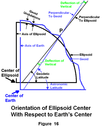
Geoid and Ellipsoid are Oriented So That
The Sum of The Squares of Several Deflections
Of The Vertical Selected Throughout The Geodetic Network
Is Made As Small As Possible
The deflection of the vertical-the angle between the plumb line and the normal to the ellipsoid-is
usually resolved into a north-south component which is equal to the difference between
astronomic and geodetic latitude; and an east-west component proportional to the difference
between astronomical and geodetic longitude. (Figure 16 shows only the north-south component.)
The Laplace equation provides a means of reconciling the azimuth differences resulting from the
use of two separate reference surfaces. Laplace equations are introduced into triangulation adjustments
to control the azimuth and orient the ellipsoid. Therefore instead of a zero deflection
at the origin as with a single astronomic position, there is a deflection of the vertical. Similarly,
the geoid separation can be determined at the origin and the ellipsoid re-oriented so that a best
average fit is provided for the ellipsoid and the geoid in the area of the Laplace stations used.
Consequently, astro-geodetically oriented datums are applicable over larger areas than those
oriented by a single astronomic position.
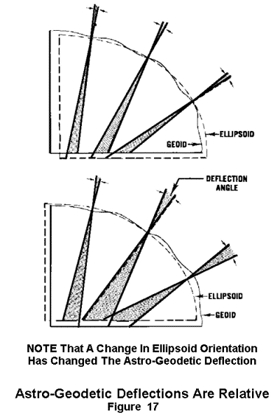
The astronomical-geodetic orientation has the disadvantage that the deflections of the vertical
remain relative. If the ellipsoid is changed, the deflections of the vertical will also change. Secondly,
it is necessary to assume a specific orientation of the reference ellipsoid with respect to
the geoid before computing the astro-geodetic deflections. Figure 17. The orientation is fixed by
the initial values of the datum origin from which the geodetic coordinates were computed. Any
change in these initial quantities will change the deflection of the vertical at each point. Consequently,
the astro-geodetic deflection of the vertical depends upon a specific geodetic datum
and the use of geodetic data developed by this method is limited to relatively small areas.
Discrepancies Between Datums
In areas of overlapping geodetic triangulation networks, each computed on a different datum,
the coordinates of the points given with respect to one datum will differ from those given with
respect to the other. The differences occur because of the different ellipsoids used and the
probability that the centers of each datum's ellipsoid is oriented differently with respect to the
earth's center. In addition, deflection errors in azimuth cause a relative rotation between the
systems. Finally, a difference in the scale of horizontal control may result in a stretch in the
corresponding lines of the geodetic nets.
In view of the different orientation of ellipsoid centers, the relative rotation between the systems,
and the scale differences; the computation of geodetic information from one datum to another
unconnected datum is quite impossible. Regardless of the accuracy of the individual datums for
computation within themselves, there is no accurate way to perform distance and azimuth
computations between unconnected geodetic systems.
With the development of both intermediate and long range defensive weapon systems, geodetic
problems have become more critical than ever before. To satisfy military requirements, it Is
necessary to provide detailed cartographic coverage of areas of strategic importance and to
accomplish geodetic computations between these areas and launch sites which are often on unrelated
datums. Both of these requirements necessitate unification of major geodetic datums by
one or a combination of existing methods.
Datum Connection
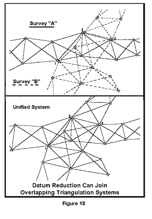
There are three general methods by which horizontal datums can be connected. The first
method is restricted to surveys of a limited scope and consists of systematic elimination of
discrepancies between adjoining or overlapping triangulation networks. Figure 18. This is done by
moving the origin, rotating, and stretching networks to fit each other. The method is usually used
to connect local surveys for mapping purposes. This method of datum transformation or datum
reduction can only be used where control exists for common points in different systems.
In addition to the classic method of datum transformation described above, there is the gravimetric
method of Physical Geodesy (Chapter V) and the methods of Satellite Geodesy (Chapter VI).
These methods are used to relate large geodetic systems to each other and/or to a world
system (Chapter VIII). Both the gravimetric and satellite methods produce necessary "connecting"
parameters from reduction of their particular observational data.
Major Datums Before World War II
By 1940, every technically advanced nation had developed its own geodetic system to an
extent governed by its economic and military requirements. Some systems were developed by
the expansion and unification of existing local surveys and others by new nationwide surveys
replacing outdated local ones. Normally, neighboring countries did not use the same geodetic
datum. There was no economic requirement for common geodetic information and the use of
common datums was contrary to the military interests of each country. The only surveys of an
international nature based on one datum were the few measurements of long arcs accomplished
for the purpose of determining the size and shape of the earth. The net result was that there
were many different surveys of varying size which differed from each other remarkably. The
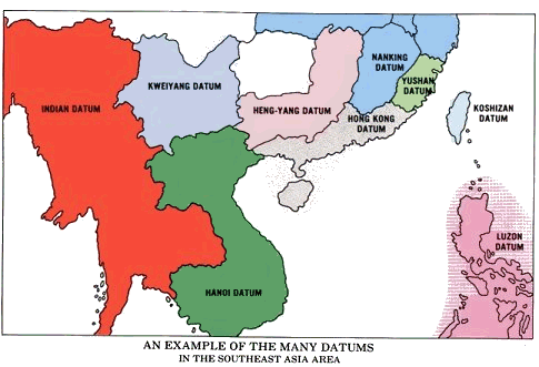
national maps based on the surveys also differed widely. Figure 19 illustrates the confusion of
geodetic information in Southeast Asia.
As military distance requirements increased, positioning information of local or even national
scope became unsatisfactory. The capabilities of the various weapon systems increased until
datums of at least continental limits were required.
The Major Datums Today
The best solution (to meeting the increased military distance requirements) was the establishment
of a "single" datum for a large area and adjusting all local systems to it. The North American,
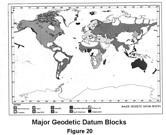
European, and Tokyo Datums were (initially) selected for this purpose. (WGS 60, Chapter VIII).
Other major geodetic datums of the world include the Arc and Adindan Datums in Africa, the
Australian Geodetic, South American 1969, Indian and the Russian Pulkovo 1942 Datum. Figure 20.
The North American Datum, 1927
The first official geodetic datum in the United States was the New England Datum, adopted
in 1879. It was based on surveys in the eastern and northeastern states and referenced to the
Clarke 1866 Ellipsoid. Through the years this datum was extended to the south and west and
in 1901, the extended network was officially designated the United States Standard Datum. The
triangulation station Meades Ranch in Kansas was selected as the origin. In 1913, Canada and
Mexico formally agreed to base their triangulation networks on the United States system. The
datum was then renamed the North American Datum. Adjusting new surveys to fit into the network
created many problems and, therefore, during the five-year period 1927-1932 all available
first-order data were adjusted into a system now known as the North American 1927 Datum.
The origin is still Meades Ranch and the datum is computed on the Clarke 1866 Ellipsoid which
was oriented by a modified astro-geodetic method. The system not only incorporated Canada
and Mexico but there are connections to the South American Datum 1969 through the West
Indies and Central America. A new adjustment of the system is currently (1982) in work. The
finished product will be called the North America Datum 1983 (NAD 83). It will be a geocentric
datum, i.e., the center of the ellipsoid will be referenced to the Earth's center of mass. The minor
axis of the ellipsoid will be oriented towards a universally accepted mean pole (a mean value
for the Earth's axis of rotation).
The European Datum
The initial point of this system is located at Potsdam, Germany. Numerous European national
systems have been joined into a large datum based upon the International Ellipsoid which was
oriented by the astro-geodetic method. The US Map Service, now known as the Defense Mapping
Agency Hydrographic/Topographic Center, connected the European and African triangulation
chains and filled the gap of the African arc measurement from Cairo to Cape Town. This work
related the Adindan Datum in North Africa, which roughly follows the twelfth Parallel, and the
Arc Datum, extending from the Equator to the Cape, to the European Datum. Through common
survey stations, a datum transformation was derived between the old Russian Pulkovo 1932 and
European systems. This extended the European Datum eastward to the 84th meridian. In 1946
the Pulkovo 1932 system was united with a basic Siberian network and the new datum was
designated the "1942 Pulkovo System of Survey Coordinates" (Pulkovo Datum 1942). Additional
ties across the Middle East connected the European with the Indian Datum.
The Tokyo Datum
The third of the initially selected datums has its origin in Tokyo. It is defined in terms of the
Bessel Ellipsoid and oriented by means of a single astronomic station. With triangulation ties
through Korea, the Tokyo Datum is connected with the Manchurian Datum. Unfortunately, Tokyo
is situated on a steep geoid slope and the single-station orientation has resulted in large systematic
geoid separations as the system is extended from its initial point.
For military distance and direction problems limited to continental areas or smaller, the large
datums were satisfactory. However, while they are improvements over the limited national datums,
they too have serious deficiencies which prevent them from providing the geodetic information
required for intercontinental ballistic missiles.
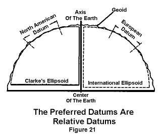
It is true that the North American Hiran tie permits connection of the European Datum and
the North American Datum. This, however, does not completely solve the problem, for both the
North American and European Datums are relative. Figure 21. While in each case the ellipsoid
chosen is an adequate fit in the area of the origin, neither provides a good fit for the entire
earth. Also, the process of connecting various datums by means of intervening datums or triangulation
ties allows errors to accumulate which do not always provide agreement with newly observed data.
The South American Datum 1969
In 1965 the Working Group for the Study of the South American Datum was asked by the
Committee for Geodesy of the Cartographic Commission of the Pan American Institute of Geography
and History (PAIGH) to establish one consistent geodetic datum for the entire continent
of South America. In June 1969, the "South American Datum 1969" was accepted by the Commission
at the IX General Assembly of PAIGH in Washington, D.C. This datum is computed on
the GRS 67 Ellipsoid as listed in Chapter II. CHUA, the National datum point of Brazil was taken
to be the origin. A vast amount of triangulation, Hiran, astronomic, and satellite data were
incorporated in the solution, and the datum now provides the basis for a homogeneous geodetic control
system for the continent.
The Australian Geodetic Datum
The survey net of Australia consists of 161 sections which connect 101 junction points and form
58 loops. Virtually all the surveys are of the traverse type in which distances were determined
by electronic measuring equipment. There are 2506 stations and the total length of the traverse
is 33,100 miles. A complete readjustment of the geodetic network was made in 1966 using the
GRS 67 Ellipsoid as listed in Chapter II. Tasmania has been connected and a tie to New Guinea
and the Bismarck Archipelago was effected by a traverse up cape York and the USAF Hiran network
of 1965. This tie placed an additional 135 points on the Australian Geodetic Datum.
The Indian Datum
The Indian Datum has been used for India and several adjacent countries in Southeast Asia.
It is computed on the Everest Ellipsoid with its origin at Kalianpur in Central India. Derived in
1830, the Everest Ellipsoid is the oldest of the ellipsoids in use and is much too small. As a result,
the datum cannot be extended too far from the origin or very large geoid separations will occur.
For this reason and the fact that the ties between local triangulation in Southeast Asia are typically
weak, the Indian Datum is probably the least satisfactory of the major datums.
Just as horizontal surveys are referred to specific original conditions (datums), vertical surveys
are also related to an initial quantity or datum. As already noted, elevations are referred to the
geoid because the instruments used either for differential or trigonometric leveling are adjusted
with the vertical axis coincident to the local vertical. As with horizontal datums, there are many
discrepancies among vertical datums. There is never more than 2 meters variance between leveling
nets based on different mean sea level datums; however, elevations in some areas are related to
surfaces other than the geoid; and barometrically determined heights are usually relative.
In the European area, there are fewer vertical datum problems than in Asia and Africa. Extensive
leveling work has been done in Europe and practically all of it has been referred to the
same mean sea level surface. However, in Asia and Africa the situation has been different. In
places there is precise leveling information available based on mean sea level. In other areas the
zero elevation is an assumed elevation which sometimes has no connection to any sea level surface.
China has been an extreme example of this situation where nearly all of the provinces have had
an independent zero reference. There is very little reliable, recent, vertical data available for
much of the area of Africa and Asia including China.
The mean sea level surface in the United States was determined using 21 tidal stations in this
country and five in Canada. This vertical datum has been extended over most of the continent
by first-order differential leveling. Concurrent with the new adjustment of the horizontal network,
mentioned previously, is the readjustment of the vertical network. Countries of North and Central
America are involved. In the conterminous United States 110,000 kilometers of the basic network
are being releveled.
[Table of Contents] [Next Section]
Figures Cleaned Up 9-9-2002 Naval Postgraduate School
Point of Contact: GOG
Phone Numbers:
Com. (314)263-4071
DSN 693-4071
Email: gandg@nima.mil
NIMA HTML Last Updated 1 February 2002