


Does this flattening have practical effects? For the user of maps the answer is probably not. For the maker of accurate maps the answer is yes. In one sense the problems have been pushed onto the map makers and geodesists. They make maps in a way to hide most effects.
The main
thing that helps with this is the way the gravity field follows the shape of
the earth. We use gravity to define up and the horizon with plumb bobs and
spirit levels.
 We are really using the
sum of the gravitational attraction predicted by Newton and the rotational effects.
This “up” turns out to be perpendicular to the ellipsoid. Thus the horizon
is tangent to the ellipsoid, just like it would be if the earth were a sphere.
We are really using the
sum of the gravitational attraction predicted by Newton and the rotational effects.
This “up” turns out to be perpendicular to the ellipsoid. Thus the horizon
is tangent to the ellipsoid, just like it would be if the earth were a sphere.
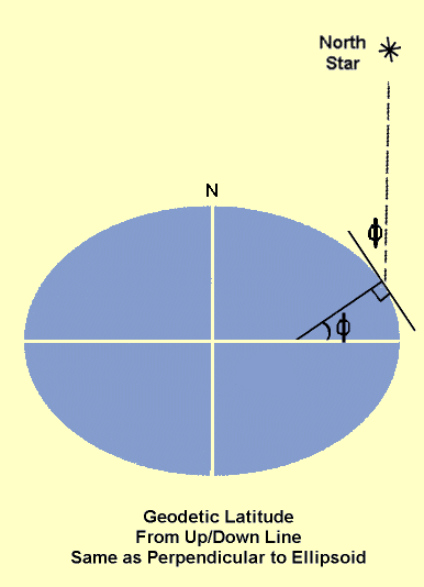
This makes the definition of latitude the same as before, just measure the difference between the horizon and the celestial pole. The down direction does not go to the center of the earth as it would for a sphere. But if you extend the "down" line it will hit the axis of the earth.
This is technically the "geodetic" or "geographic" latitude. There are many kinds of latitude needed in precise surveying and geodesy. But the geodetic latitude is the kind found on maps. The geometry of geodetic or geographic latitude is shown below. The line perpendicular to the ellipsoid does not point to the center of the earth. It does hit the polar axis though. The angle that this "up-down" line makes with the equator plane is the geodetic latitude. It is the angle found using the north star, assuming that there are no bumps in the gravity field. (More on that small effect later.)
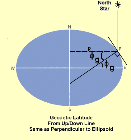
Notice that the moment arm for the rotational acceleration, p, is one side of a triangle using this extended down line. This triangle has the geodetic latitude in it.
Observable Effects – Pendulum Clocks
The first effect of the equator bulge that scientists observed was errors in pendulum clocks. The length of the pendulum and the force of gravity determine the rate of the clock. But the force of gravity gets weaker as you go up in altitude. This makes the force of gravity smaller on the equator and clocks run slower there. In fact this is how Newton got the idea for an elliptical earth. A clock calibrated in Paris ran slow by about two minutes a day when taken to South America nearer the equator.
Map Makers Earth Models
In order to convert survey measurement of distances and angles to a map, the shape of the earth is needed. In the past this was taken as a sphere. Now the measurements are accurate enough that an ellipsoid must be used. Even the inexpensive GPS receivers have to use ellipsoid models of the earth to calculate the latitude displayed to the user.
However, the precise values of the ellipsoid ( a and f or a and b ) are hard to measure. You need precise data from all over the world. If you only have data from a "small" part of the earth, your estimates of the true shape of the earth are skewed. In this context all of North America is a small part of the earth.
Therefore different ellipsoids were generated in different parts of the world and even in different countries close to each other. This is the topic of the next section.
|
|
||||
|
|
|
|
|
|