


Latitude and Longitude in the Real World
Overview
The world is not a sphere. The true shape is a rotated ellipse. The shape is defined by the sum of the Newtonian gravitational force and rotational effects. This causes the direction "up", as sensed by a bubble level or plumb bob, to be perpendicular to the ellipsoid.
This effect, makes the operational definition of latitude the same as for a spherical earth - find the angle between the horizon and the polar axis.
The diagram below defines the latitude we really find on maps. It was also given in the shape of the world section. The geodetic latitude is defined by the angle the up-down line makes with the equator. This line is perpendicular to the ellipsoid. The local horizontal is the tangent to the ellipsoid.
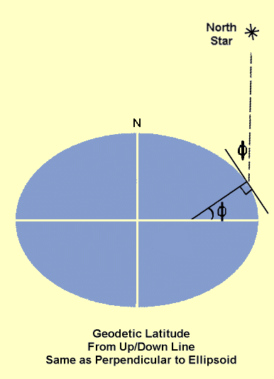
This is not quite the way latitude is defined, but it is very close. There are very small differences between the horizontal - defined by local gravity, and the perpendicular to the ellipsoid. These are caused by very small variations in the earth's gravity field - due to mountains and other "small scale" inhomogeneities. The differences are a few arc seconds at most.
The latitude obtained from star observations and using a bubble level for up are called astrodetic latitudes. They will not be considered further here. The latitude on maps, geodetic latitude, is defined from the perpendicular to the ellipsoid. This is a simple mathematical concept because the ellipsoid is a simple math object. In the real world finding this version of up is complicated. Modern satellite navigation systems have simplified this task though.
In this section we will discuss the different types of latitude and longitude. There and now three radii that are used for different purposes, where there was only one for a sphere. This will be explained.
|
|
||||
|
|
|
|
|
|