


Projection Example - UTM
The Mercator projection does fairly well near the equator. The idea for the Universal Transverse Mercator, UTM, is to rotate the cylinder on its side and make it trangent to the earth along a meridian (line of constant longitude). Then the projection will only be used in a 6 degree belt or stripe centered on this longitude. This is like a standard Mercator within 3 degrees of the equator.
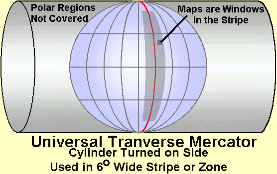
This projection is limited to latitudes of 84 N and 80 S. This is to limit the error from the converging lines of longitude at the poles. In the polar region, a azimuthal (planar) projection is used.
The UTM is also a "windowed" projection. The projection is for the entire stripe (within latitude limits). Maps are just small windows cut from this large projections that are scaled up. This means that UTM maps from the same zone will fit together at the edges.
In order cover the earth, the idea of zones in introduced. The first zone is in the Pacific ocean between 180 E and 186 E. The tangent line is 183 E. A second zone is six degrees east, between 186 E and 192 E (this is 174 W to 168 W). It takes 60 zones to cover the earth.
A feature of the UTM is that the cylinder is depressed in the earth. This has the scale factor along the central meridian as 0.9996. This is .04 percent. (40 cm / km ) The distortion at the edge depends on latitude. At high latitude is can be up to .25 percent ( 2.5 m / km ). Most large scale (small area) maps have less distortion than the UTM at high latitudes.
|
|
||||
|
|
|
|
|
|